Showing posts with label geology. Show all posts

Thursday, 1 August 2013

Sepia Saturday 188: The Cornwall Coast in Colour


Sepia Saturday by Alan Burnett

A couple of months ago I purchased a large collection of glass plate negatives, and used several of these to illustrate a piece I wrote for Sepia Saturday about a visit to the Pleasure Palaces of Southport. In the second of a planned series of articles about this intriguing collection we return to the English coastline with six colour positive glass plate slides taken by an unknown amateur photographer.

The six slides each measure 89 x 63mm (3½" x 2½"), with the printable area roughly 3¼" x 2¼", corresponding to the standard quarter-plate format used by most amateur glass plate cameras in the early to mid-1900s. All six are coastal views but, like the rest of the collection, none have anything to indicate where they might have been taken, despite having a very English feel to them.

Image © and collection of Brett Payne

It was this view that provided the first clue. As a trained geologist I'm pretty familiar with landscapes and outcrop patterns produced by a variety of rock types, and this headland with its blocky nature produced by weathering of rectangular joint patterns seems to me very typical of granite.

Image © and courtesy of the Ordnance Survey
Geology of Cornwall and Devon
portion of Geological Survey "Ten-Mile" Map (1957)
Image © and courtesy of the Ordnance Survey

From what I remember of my A-Level geology studies the only place in England that you're likely to find granite right on the coast is in Cornwall, as the portion of the Geological Survey map for that area shows rather dramatically. The red blobs are granite intrusions, and the blob at the far left covers the land around Penzance, St Ives and Land's End.


Land's End, Cornwall
View Larger Map

That still leaves a fair distance of coastline to search, but if you're visiting Cornwall, what better place to take a photograph than at Land's End, that most touristic and memorable of spots, so that's where I looked first. You can search this coastline very effectively using either Google Maps or Google Earth. Noticing that the view in that first slide had some rocks off shore, with perhaps a lighthouse on one of them, I used Google Maps to come up with this view of rocky islets a few hundred metres to the west of Land's End.

Image © Tom Hurley and courtesy of 360 Cities
Land's End, Cornwall
Image © Tom Hurley and courtesy of 360 Cities

Google Earth gives you the opportunity to "fly through" the landscape in virtual 3-D, and to access "spherical panoramic" images hosted by 360 Cities. One of these fortuitously shows almost the exact view as in the slide, taken from Dr Syntax's Head with the Longships islets and lighthouse, as well as Kettle's Bottom rock, in the distance.

Image © and collection of Brett Payne

Walking a few metres out to the headland and turning right to face north-east gives us the scene shown in the second of the slides (above). The rugged coastline is identifiable by the characteristic sea arches, and a hotel building just visible on the horizon. These two panoramas can be viewed via browser on the 360 Cities web site here and here.

Image © and collection of Brett Payne
Harbour View A

The next three slides show a harbour, taken from different spots around the shoreline. This image is the most interesting, and in some ways frustrating, of the three. A large crowd gathers around something almost hidden from the view of the photographer. In the right foreground a neatly dressed woman pats the neck of a horse, complete with full collar and harness attached to the shafts of the cart, the buckboard of which is just visible through the crowd. Clearly the people are jostling for a closer view of whatever is on the cart. One man, wearing rolled up shirt sleeves and a flat cap, is standing at what is probably the tailgate of the cart, and has the attention of many in the crowd. At far left of the foreground, standing on some kind of platform, are three teenagers including two girls with dark blue school blazer, one with an unidentifiable crest.

A lorry with large drums piled on the back is parked between the crowd and the water. Almost hidden behind the cab of the truck, several boys play in waist-deep water. The harbour is scattered with boats at anchor, ranging from small pleasure craft to larger commercial fishing boats. A long stone wharf or breakwater extends almost across the entire width of the photo, with two lighthouses, a large one centrally placed and a smaller one at the distal end, marking one side of the harbour entrance. A couple of dozen cars, mostly black, are parked along the wharf, reminding one of that well worn quote often attributed to Henry Ford, "You can have any colour as long as it's black." The car at the far right looks like an early Morris Minor, first manufactured in 1948. Also arrayed intermittently down the wharf are a number of people standing and sitting, obviously enjoying the warm sunshine.

Image © and collection of Brett Payne
Harbour View B

This view of the harbour includes the shore-end of the wharf and part of a town, with a number of boats resting at anchor and several dinghies tethered by ropes and lying on the sand in the foreground exposed by an outgoing tide.

Image © and collection of Brett Payne
Harbour View C

A third view of the harbour is taken from the opposite direction, the photographer standing on the shore somewhere in the middle of the previous view. Boats are at anchor or under way in the small harbour, at least four of them with visible occupants, and several men, women and children can be seen on foot investigating the intertidal sand flats.

The slopes on the other side of the harbour are clad with a substantial number of buildings, indicating a sizeable town, and a smaller wharf protecting the other side of the harbour is visible in the left middle ground. At far left in the middle ground, beyond a rocky point, a beach crowded with pleasure seekers can just be made out.

Image © and courtesy of Google Earth
St Ives, Cornwall, December 2005 (see in Google Maps)

It took a little searching, but I eventually found the harbour using Google Earth. It is St Ives, situated on the northern Cornwall coast, a town well serviced with Streetview images, which meant I could locate three perfect shots for a "Now and Then" series.

Image © and courtesy of Google Earth
St Ives Harbour View A - May 2009
Image © and courtesy of Google Earth

The first view was clearly taken near the top of this boat ramp, and I suspect the cart contains a catch of fish, crab or lobster recently hauled onshore from one of the fishing boats now at anchor in the harbour.

Image © and courtesy of Google Earth
St Ives Harbour View B - May 2009
Image © and courtesy of Google Earth

Image © and courtesy of Google Earth
St Ives Harbour View C - May 2009
Image © and courtesy of Google Earth

The second and third views indicate that the photographer was walking around the harbour as the tide went out.

Image © and collection of Brett Payne

The last of the six slides depicts a beach at low tide, filled with dozens of people enjoying the sunny afternoon. Some recline in their deck chairs, reading newspapers, chatting to friends or watching the children playing. The photographer has caught a young boy having just bowled a ball at his sister, and she's in the act of batting it away. Two young ladies bravely sunbathe in the lea of a rocky outcrop. Another group of children are digging in the sand. One young man or woman scans the sky anxiously, wondering how much longer the sun will last or perhaps keeping a lookout for pesky seagulls.

Image © and courtesy of Google Earth
View of Newquay Harbour entrance from Towan Beach
Image © buthe79 and courtesy of Panoramio

This has been identified as Town Beach at Newquay, which recent images show to have remained popular with holidaymakers. The rocks here are Devonian sandstones, by the way.

The clothing fashions in these photographs, particularly those worn by the women, appear to me to be typical of the post-Second World War era, i.e. the late 1940s and early to mid-1950s, illustrated by the images on Geoff Caulton's PhotoDetective web page for this period.

Image © and collection of Brett Payne
Detail of St Ives Harbour View A
Image © and collection of Brett Payne

It was when zooming in on these images that I noticed a very unusual feature, one that I've never previously noticed in any of the colour images that I own. Although not visible to the naked eye, the colours are actually made up of three differently coloured sets of diagonal lines. According to Robert Hirsch's history of colour photography (Hirsch, 2011), colour plates made up of a "checkerboard of red, green, and blue elements" were produced by the Finlay Colour process, also known as the Thames Colour Screen, which was originally patented in 1906 but abandoned after the Great War. It was subsequently re-introduced in the late 1920s and early 1930s.

The Paget Dry Plate process, "patented in Britain in 1912 by G.S. Whitfield and first marketed by the Paget Prize Plate Company in 1913," was a very similar technique (Wikipedia).

The system used two glass plates, one of which was the colour screen plate while the other was a standard black-and-white negative plate. The colour screen plate comprised a series of red, green and blue filters, laid down in a regular pattern of lines to form a réseau, or matrix ... Transparency positives could be made from the system's panchromatic negatives by contact printing; these positives were then bound in register with a colour viewing screen of the same type as used for exposure, to reproduce the image in colour.
James Morley has a small collection of early colour positive slides produced by the Paget process here. My examples, however, appear to have been taken considerably later, probably in the very late 1940s or early 1950s.

For more coastal excursions, in various hues, visit the other participants in this week's Sepia Saturday effort.

References

Hirsch, Robert (2011) A Concise History of Color Photography, in Exploring Color Photography, 5th Edition, Focal Press.

Elusive colour: Paget colour system, on Captured in Colour, Australian War Memorial.
Thursday, 27 June 2013

Sepia Saturday 183: A Return Trip to Dovedale


Sepia Saturday by Alan Burnett and Kat Mortensen

This week's Sepia Saturday photo of a group of intrepid adventurers posing at the entrance to a limestone cave system in New South Wales gives me an opportunity to make a return visit to Dovedale in the English Peak District, which I have featured a couple of years ago: Donkey Rides at Dovedale and The Compleat Angler, a Derbyshire Fishing Trip.


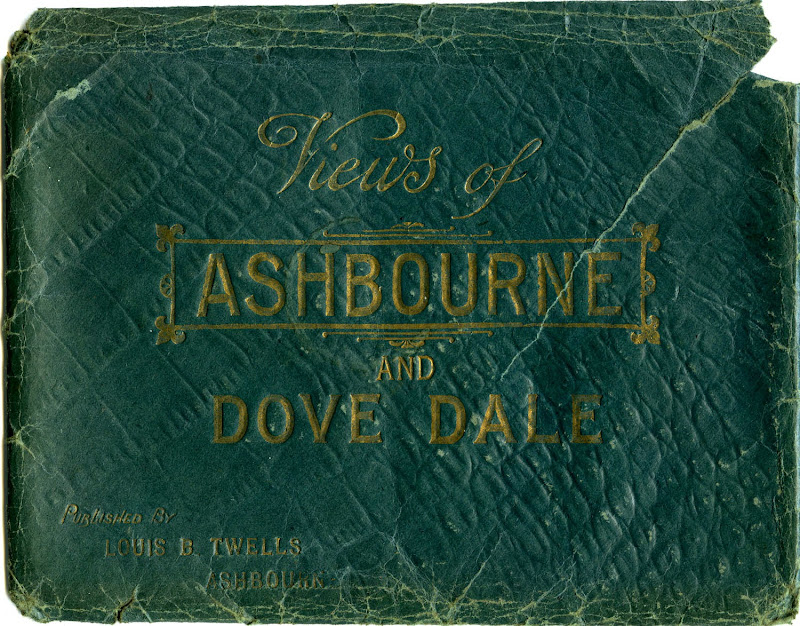
Views of Ashbourne and Dove Dale
Published by Louis B. Twells, Ashbourne

This time I can use a couple of more recent acquisitions, purchased for very modest sums on eBay. The first, a large envelope made of green paper with a shiny, faux crocodile skin finish and gold print, contains 32 black-and-white and blue-tinted lithographic prints, each measuring approximately 205 x 151mm (8" x 6"). The title on the envelope simply states, "Views of Ashbourne and Dove Dale" - which indeed they are - published by Louis B. Twells of Ashbourne.

Louis Bosworth Twells (1829-1885) settled in Ashbourne (Derbyshire) around 1855, and over the next three decades conducted a variety of trades: hair cutter/dresser, perfumer, jeweller, silversmith, watch maker, importer of general fancy goods, sponges, &c., and proprietor of "large show rooms for glass, china, and earthenware." I have seen a single example of a carte de visite portrait which he also "published." There is no direct evidence that he took any photographs himself, but he may well have done. After his death in 1885 his widow and son, also named Louis B. Twells, continued to operate the business until 1903.


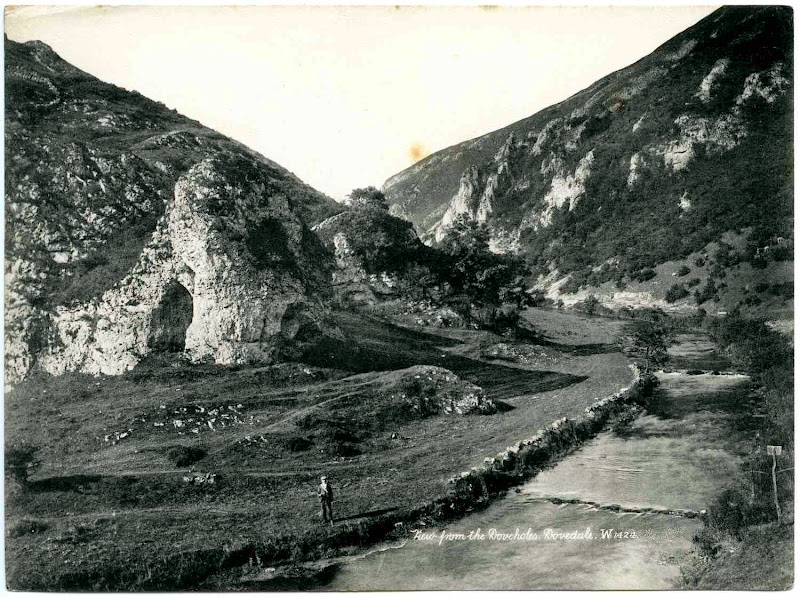
View from the Doveholes, Dovedale (Ref. W. 1424)
Original photograph publ. by James Valentine & Co.
Lithographic print publ. by Louis B. Twells, Ashbourne

This view of Dovedale from the mouth of the limestone cave known as Dove Holes is one of 16 prints of excellent quality which don't carry the name of either photographer or publisher. A detailed examination of the prints reveals artefacts suggesting that they were reproduced from carefully retouched photographic prints.


After some deliberation I've decided that the text so carefully pencilled out in this image included a negative number and the original publisher's initials:

1424 JV + Co. Ltd
in the characteristic cursive script used by famous postcard publisher James Valentine & Co. of Dundee. However, I've yet to find an example of the original photograph published by Valentine.


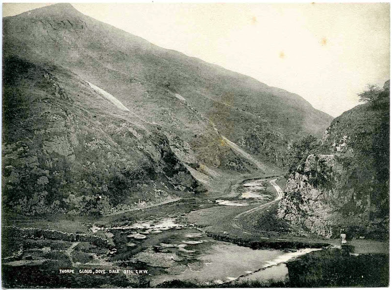
Thorpe Cloud, Dovedale (Ref. 3921)
Original photograph publ. by George Washington Wilson

A second group of 16 prints show similar landscapes. Although of slightly poorer reproduction quality, these views are still very professionally composed, and are annotated with the initials "G.W.W." This indicates that they were originally published by George Washington Wilson & Co. of Aberdeen, another Scottish photographer who became one of the largest publishers of photographic prints in the world, rivalling the business of Valentine and Sons.

Image © and courtesy of University of Aberdeen Library, Special Collections and Museums
In Dovedale Looking Up Entrance to Dale, (Ref. 3923)
Glass plate negative 220 x 170mm by G.W. Wilson & Co. of Aberdeen
Image © and courtesy of University of Aberdeen Library, Special Collections and Museums

The University of Aberdeen Library has an enormous collection of 45,000 of George Washington Wilson's glass plate negatives, the original photographs taken between 1853 and 1908, with digitized images online. There are 488 views of Derbyshire alone and the web site is well worth a visit. I wasn't able to find the same view, but I did find a similar one, with a negative number (3923) suggesting that it was probably taken on the same occasion.


Views of Ashbourne and Dovedale
Images © and collection of Brett Payne

The remaining views from the Ashbourne & Dovedale collection can be seen in this slideshow created with Picasa. It's difficult to know now if all 32 of the prints were originally sold in this wallet, or whether the G.W. Wilson prints were added later by a previous owner. However, from what I can tell, they appear to have been taken over roughly a decade from the mid-1880s through to the mid-1890s. Photographs mounted on glossy card of the particular shade of dark green used for the envelope were very popular in the 1890s, and I suspect that Louis Twells Junior was selling this collection at this time.

Images © and collection of Brett Payne
Unidentified group at Twelve Apostles' Rock, Dovedale, c.1900-1910
Lantern slide (83 x 83mm) by unknown photographer
Images © and collection of Brett Payne

My other purchase was a small group of lantern slides, almost certainly taken by an amateur, two of which depict an outdoor excursion by a small group of young men and women. Although not annotated, the view above is identifiable as the River Dove in the vicinity of Twelve Apostles' Rock, also shown in one of the prints by G.W. Wilson in the slideshow above.

Images © and collection of Brett Payne
Unidentified group, probably at Dovedale, c.1900-1910
Lantern slide (83 x 83mm) by unknown photographer
Images © and collection of Brett Payne

A second image shows three men and four women seated on a hillside, judging by the nature of the scree, probably the lower slopes of Thorpe Cloud or one of the adjacent hills flanking the entrance to Dovedale. If, as seems likely, the group consisted of four young couples, a fourth man is probably taking the photograph. One of the other slides in this small collection is dated 1906, and the clothing fashions of the women in the photo suggest that these are from a similar time period.

Image © and courtesy of the Tauranga Heritage Collection
Magic Lantern Projector
Image © and courtesy of the Tauranga Heritage Collection

The second half of the nineteenth century saw a huge expansion in the number of people taking trips to the seaside and day excursions into the country. Pictorial mementos available to the everyday tourist included scenic images in the form of stereoscopic cards, carte de visites and unmounted prints published by both local firms and by larger enterprises such as Valentines and G.W. Wilson.

During the 1890s and early twentieth century advances in camera design and technology made them considerably cheaper and more portable. As a result, excursionists were able to create their own mementos as they enjoyed their holiday. These lantern slides were most likely produced by direct printing on thin glass slides from original glass-plate negatives, and would have been displayed with a magic lantern projector similar to that shown above.

References

Postcard Publishers, Printers, and Distributors of Note by the Metropolitan Postcard Club of New York City.

The George Washington Wilson and Co. Photographic Collection, University of Aberdeen Photographic Archive.

George Washington Wilson Collection online.

Thursday, 21 February 2013

Sepia Saturday 165: Sojourn in Swanage


Sepia Saturday 165 by Alan Burnett and Kat Mortensen

In the past I have frequently mined my own family photograph collection for both inspiration and subjects for articles on Photo-Sleuth. Hunting for appropriate images or interesting topics often involves looking at the photographs in greater detail, or perhaps from a different point of view. Occasionally this results in the unearthing of new clues regarding the people in the photo or the events depicted, part of the process that Alan Burnett has referred to as "photographic archaeology."

The Sepia Saturday prompt this week invites us to share "unknowns" from our collections. My contribution is the result of an investigation into a series of three amateur photographs from my family collection from geographical, genealogical and photohistorical perspectives.

Image © and collection of Barbara Ellison
Charles Hallam and Sarah Payne promenading at Blackpool, c.1900-1904
Cabinet card by H. Pawson, Promenade Studio, Blackpool
Image © and collection of Barbara Ellison

My great-great-uncle Charles Hallam Payne (1870-1960) and his wife Sarah Emma Payne nee Parker (1870-1946) retired from running the Payne family grocery in June 1914, when they were in their mid-forties, moving from Normanton to Dale Cottage near Ingleby. Retiring at such a young age was probably facilitated by a substantial inheritance from Hallam's father, and perhaps precipitated by the death of his mother earlier that year.

The lease on Dale Cottage was signed four days before Archduke Franz Ferdinand was assassinated in Sarajevo, and when war was declared against Germany six weeks later, Hallam and Sarah must have wondered if they'd made a mistake. No doubt the privations and hardships brought on by the Great War impacted on far more than just their tradition of having regular summer holidays at the seaside, such as that captured by Harold Pawson at the Promenade Studio portrait above, taken shortly after the turn of the century.

Image © and collection of Barbara Ellison
Charles Hallam Payne (far right) and friends, Swanage
Postcard print by unidentified photographer, 10 June 1929
Image © and collection of Barbara Ellison

They resumed their outings some time after the war had ended and, according to inscriptions on the backs, these three amateur prints were all taken in the summer of 1929 at Swanage on the southern coast of Dorset, England. This was after one of the most severe winters of the last three decades and a notably dry spring, but in typical English fashion they are dressed for inclement weather, quite a contrast to the German family holidaying in Sorrento which I featured on Photo-Sleuth six weeks ago.

It was also less than a fortnight after the General Election, the first in the United Kingdom in which women under 30 were allowed to vote, and therefore often referred to as the "Flapper Election." Did the young women perched not far from the edge of a cliff in this photograph vote? I like to think so, although perhaps they were a little young.

Image © and collection of Barbara Ellison
Reverse of K Ltd postcard, probably taken with a No. 3A Folding Pocket Kodak or similar, using 122 roll film and processed by Kodak Ltd.

The backs of two of the postcard-sized photographs in this series display a generic "K Ltd" format which Ron Playle lists as in use from 1918 until 1936. Although he doesn't state the name of the firm who printed them, I believe these very commonly used postcards are very likely to have been produced by Kodak Ltd., like the similar "K" design from the late 1930s and early 1940s which was from Kodak, and which I wrote about last week.

This excerpt from an article by Merril Distad provides more background to Kodak's early involvement in the postcard industry:
Kodak’s greatest boost to the postcard craze really began in 1903 with the introduction of the Kodak Folding Pocket Model 3A camera. Produced until 1941, it was a small, folding bellows camera, priced from as low as $12, that yielded postcard-size negatives (3.25 x 5.5 inches / 83 x 139 mm). Kodak distributed its photo print papers, both the “Velox” and (after 1904) the cheaper “Aso” brand, precut to the same size, with the standard postcard grid format printed on the backs. Despite competition from other companies’ photo papers in postcard format, such as Ansco’s “Cyko,” Artura’s “Artura,” Burke & James’ “Rexo,” Defender’s “Argo,” and Kilburn’s “Kruxo,” Kodak papers accounted for 70 percent of such sales prior to 1914, while it sold an annual average of 45,000 Model 3A cameras during the same period.
Many of Derbyshire's commercial photographers used "K Ltd." postcard papers for their own photos in the 1920s. Some firms, such Boots Cash Chemists, which had four branches in Derby and a further 11 throughout Derbyshire, would also have provided a service which developed and printed roll film from cameras such as the No. 3A Folding Pocket Kodak.

Image © and collection of Barbara Ellison
Sarah (2nd from left) & Charles Hallam Payne (far right) et al, Swanage
Postcard print by unidentified photographer, 10 June 1929
Image © and collection of Barbara Ellison

Buoyed by the recent successful identification of the Sorrento coastline, I wondered whether it might be possible to pinpoint the spots where these photographs had been taken, even though I am as unfamiliar with England's southern shoreline as I am with the Italian coast.

Although not the best in terms of clarity, the first shot shows Uncle Hallam with a young man and two young women - one with a hat, one without - posing on what appears to be the edge of a cliff, overlooking a body of water with some rocks just visible at centre left.

The second has the same group, with the addition of Aunt Sarah, standing at the edge of a road bordered by an untrimmed hedge. The chimneyed roof of a cottage is visible at centre right, and a view of the sea at centre left, with a possible "notched" headland in the distance.

Image © and collection of Barbara Ellison
Sarah (2nd from right) & Charles Hallam Payne (far right) et al, Swanage
Amateur paper print by unidentified photographer, June 1929
Image © and collection of Barbara Ellison

The third shot appears to have been taken at a similar location to the first, although Aunt Sarah and Uncle Hallam, his hat now carefully placed on the ground, are now standing with two young men and one young lady. It seems likely that the young woman without a hat who appears to be wearing a man's dark jacket in the first cliff-top shot was the photographer in this third photograph.

Image © and collection of Barbara Ellison
Amateur print (60x88mm) on Velox paper by unidentified photographer
Probably taken with Folding Pocket Kodak or No. 2 Brownie, June 1929
Image © and collection of Barbara Ellison

The quality of this paper print, clearly marked with Kodak's VELOX brand, is somewhat inferior to the other two and it is a smaller format. It measures roughly 2¼" x 3¼", which equates to Kodak's 105 or 120 formats, and therefore probably taken with either a Folding Pocket Kodak or a No. 2 Brownie.

Image © and courtesy of Google Earth
Swanage and Peveril Point
Image © and courtesy of Google Earth

Next ... the location, which I investigated, as usual, using the imagery provided by Google Earth. To the east of Swanage's town centre, at the southern end of a large bay, is a peninsular called Peveril Point, which seemed to me the most obvious place to go looking for cliff tops that tourists might visit.

Image © Al Dunn and courtesy of 360 Cities
View of Broken Shell Limestone Reef, Durlstone Bay from Swanage Coastguard Hut, Peveril Point
Image © Al Dunn and courtesy of 360 Cities

Close to the tip of Peveril Point, not far from the Coastguard hut, and right on the cliff edge, Google Earth shows a small red icon which represents a 360 degrees panoramic view. Double-clicking on the icon takes one into the panorama, and provides the image above, apparently taken from precisely the same spot as the first cliff-edge photograph.

The rocky outcrop known in geological circles as the Broken Shell Limestone Reef is clearly visible, even at high tide, as are the the white shells or pebbles which litter the ground at the cliff top. This forms part of the geological type-section of the Purbeck Group of the Upper Jurassic, visited frequently by geologists and geological students since its first description by Thomas Webster in 1816, and well known for its reptile and early mammal fossils (West, 2012).

Image © Andy Jamieson and courtesy of Geograph.co.uk
Coastguard cottages overlooking Swanage Bay
Image © Andy Jamieson, courtesy of Geograph.co.uk and licensed for reuse under this Creative Commons Licence

Despite the loss of two of the building's chimneys in the intervening eight decades, it is easily identifiable as the Coastguard Cottages which are situated immediately above the RNLI Swanage Lifeboat Station.

Image © Bressons_Puddle and courtesy of Panoramio
The Coastguard Cottages on Peveril Point, Swanage
Image © Bressons_Puddle and courtesy of Panoramio

Image © and courtesy of Google Streetview
Peveril Point Road, Swanage
Image © and courtesy of Google Streetview

Unfortunately Google's StreetView camera didn't quite make it that far along Peveril Point Road, but the cottages and their chimneys are just visible poking out to the left of the small tree in the centre of this view above (click on the image to be taken to StreetView). Very close to the blue gate set into the stone wall in front of the tree is where the group of five were standing on that summer evening.

Image © and courtesy of Google Earth
Swanage and Peveril Point, with the two camera positions marked
Image © and courtesy of Google Earth

I write "evening" because the photographer is facing towards the north-east. The characteristic profile of the cliffs at Ballard Point and Old Harry's Wife, on the other side of Swanage Bay, are just visible - the "notched" headland to which I referred earlier. The shadows are long and pointing towards the east, and since in Dorset the sun sets around 9:20 pm in mid-June, I estimate this was perhaps between 5 and 7 pm.


The Promenade, Swanage, Postcard postmarked 1931

Although other visitors aren't visible in any of these photographs, Swanage was a popular destination between the wars, as evidenced by the number of postcards from that era boasting of its amenities, such as the view of The Promenade above, posted on 1931.

Image © and courtesy of Una Palmer
Mary and Ella Chadwick, 1927
Postcard print by H.A. Aylward of Alton, Hampshire
Image © and courtesy of Una Palmer

Lastly to the identification of Hallam and Sarah's fellow sojourners on Swanage. Hallam and Sarah didn't have any children of their own. So whose kids did they have, then (you might ask, if you're a Spike Milligan devotee)? Well, they were very fond of their nephews and nieces, grand-nephews and grand-nieces, including my grandfather and father.

One of the two young women was, I think, Mary (born in 1912, shown above left), a daughter of Hallam's sister Lucy Mary (aka "Maggie") Chadwick (1876-1953), probably the one wearing the sensible hat. Maggie's younger daughter Ella (aka "Bay" and born in 1916, above right) was only twelve years old at that time, so I think the other young woman - the one I suggest may have wielded a camera - is probably a friend. The Chadwicks were living at Headley Down in Hampshire at this time, which would have been two or three hours' drive from Swanage in Hallam's Citroën purchased in July 1921 (either a Type A, the first motor car mass-produced in Europe, or a Type B).

Image © and courtesy of Una Palmer
Harry and Clarence Benfield Payne, c.1919-1921
Postcard print by unidentified photographer
Image © and courtesy of Una Palmer

As for the two young men, I feel sure they are the sons of Hallam's younger brother Fred Payne (1879-1946) and drove down with them from Derby. Henry (aka Harry and born in 1906) and Clarence Benfield (born 1907) both lived in Derby, where their parents had been running the grocer's shop/offlicence in St James' Road, Normanton ever since Hallam and Sarah's retirement. Their sister Christine was captured walking with her uncle and aunt twice by street photographers in Bournemouth four years later.

References

Gustavson, Todd (2009) Camera, A History of Photography from Daguerreotype to Digital, New York: Sterling, 360 pp.

Distad, Merrill (nd) The postcard – a brief history, on Peel's Prairie Provinces, from University of Alberta Libraries.

Milligan, Spike (1961) Word Power, on Milligan Preserved, LP publ. EMI (NTS 114), courtesy of YouTube.

West, Ian M. (2012) Durlston Bay - Peveril Point, Durlston Formation, including Upper Purbeck Group: Geology of the Wessex Coast (Jurassic Coast, UNESCO World Heritage Site), Internet geological field guide, by Ian West, Romsey and School of Ocean and Earth Science, National Oceanography Centre Southampton, Southampton University.

Sunrise and Sunset in Bournemouth

Historical Weather Events

Excerpt from Kelly’s Directory of Hampshire 1931, courtesy of John Owen Smith

The AA Road Book of England and Wales, publ. c.1936 London: The Automobile Association, by kind courtesy of Nigel Aspdin,

Wednesday, 15 June 2011

George Valentine and the Hot Lakes

Image courtesy of Timeframes & the Alexander Turnbull Library
Mount Tarawera in eruption, 10 June 1886 [1]

At 2.30 in the morning on Thursday 10th June 1886 - 125 years ago last Friday - many Auckland residents were woken by a continuous series of loud, but distant, explosions. Flashes could be seen on the horizon and it was assumed, even by writers compiling the early edition of The New Zealand Herald, that some vessel in the Manukau Harbour had exploded [2]. If George Valentine, his wife Minna and their three children, by some chance, did not wake until a more respectable hour, they would soon have heard the news, even at their home in the borough of Parnell. By nine o'clock the Auckland Evening Star offices had received reports of a "tremendous outburst of volcanic activity ... in the Rotorua District, surpassing anything of the kind ever experienced in New Zealand." [3]

Image courtesy of Timeframes & the Alexander Turnbull Library
Te Wairoa Township, c.1886 [4]

Valentine was familiar with the "Hot Lakes," having visited Rotorua and the nearby Lakes Tarawera and Rotomahana early the previous year on a photographic excursion. George Dobson Valentine (1852-1890) was a son of the renowned Scottish pioneer photographer and publisher of views James Valentine (1815-1880). After his father's death, he and his brother William had continued to expand the photographic business.

Image courtesy of Timeframes & the Alexander Turnbull Library
"In The Tiki Tapu Bush" - January 1885 [5]

However after being diagnosed with tuberculosis, he emigrated to New Zealand with his family in 1884, in the hope that the climate would revive his health. Initially settling in Nelson, he had begun publishing photographic views under his own name, and one of his earliest projects was a photographic expedition to the Rotomahana District, near Rotorua, with Auckland bookseller Charles Chapman.

Image courtesy of Timeframes & the Alexander Turnbull Library
"Rotomahana Hotel, Te Wairoa" - January 1885 [6]

From Auckland, they travelled via Cambridge, Oxford (now called Tirau) and Rotorua over several days in January 1885. The journey to Te Wairoa, on the shores of Lake Tarawera, was a shorter leg, and they were able to spend some time admiring the pristine podocarp forest at Tikitapu. They spent the night at Joseph McRae's Rotomahana Hotel, and obtained permission from the local chiefs to camp at the famous Pink and White Terraces.

Image courtesy of Timeframes & the Alexander Turnbull Library
"White Terrace and Lake Rotomahana" - January 1885 [7]

Early the following morning on 13 January 1885 Valentine and Chapman departed by whale boat across Lake Tarawera to the small settlement of Te Ariki. They were accompanied by Guide Sophia, chief Tamihana Te Keu, a small group of tourists and the crew. A short walk then ensued to the "warm lake" Rotomahana, where the vista opened up to reveal the famed Te Tarata or White Terraces. Coincidentally, artist Charles Blomfield was camped nearby, in the middle of a lengthy stay during which he would paint a number of now well known views of the terraces.

Image courtesy of Timeframes & the Alexander Turnbull Library
"Coffee Cups, White Terraces" - January 1885 [8]
Clik image to read full series of articles

They set up camp close to the White Terraces and remained for several days, during which time Valentine produced over 40 scenic views with his glass plate camera, including this atmospheric image of the almost waxy looking siliceous basins with a fine veil of steam. After his return home to Nelson, these views were later published and marketed by Chapman. One of them was awarded a second prize at the New Zealand Industrial Exhbition in August, pipped at the post by Alfred Burton of Dunedin.

Image courtesy of Papers Past and the National Library of New Zealand
Great Volcanic Eruption. Terror in Hot Lake District
The Auckland Evening Star, 10 June 1886 [3]

The Valentine family had moved to Auckland in October 1885, and had therefore been living there for some eight months on the morning that the dreadful news broke concerning the "terror in the Hot Lake district." News of the tragic loss of life was greeted with dismay, almost matched by the despair at reports of the devastation, affecting both personal property and the countryside, and including the Pink and White Terraces.

Image courtesy of Timeframes & the Alexander Turnbull Library
"Tiki-Tapu Bush, After Eruption" - October 1886 [9]

Photographers were on site recording the devastation within days, but George Valentine did not make it there until early October. He and Chapman were accompanied by Joseph McRae, whose hotel at Te Wairoa had been all but demolished in the ash fall, and guide Alfred Warbrick. The luxurious bush at Tikitapu was now an array of bare wooden tree trunks, sadly stripped of all signs of the green thicket captured so vividly the previous year.

Image courtesy of Museum of New Zealand/Te Papa Tongarewa
"Te Wairoa. McRae's Hotel, Sophia's Whare and Terrace Hotel" - October 1886 [10]

They sheltered for the night in what remained of McRae's collapsed hotel before being rowed across the lake to Te Ariki. The scenes which they encountered, and which Valentine photographed, revealed a landscape denuded of all vegetation, and most recognisable landmarks were obliterated with a thick blanket of grey volcanic ash. Smoke and steam were spurting out of the ground in many locations, and when they reached the former site of the White Terraces, the valley had been filled with an enormous lake, several times the size of the original Rotomahana.

Image courtesy of Timeframes & the Alexander Turnbull Library
"Rotomahana, from Hape O' Toroa" - October 1886 [11]

Both the Pink and White Terraces were gone, replaced with the all encompassing tephra field, criss-crossed with erosion gullies and hard to traverse. Valentine returned to the area a month later to take further photographs of the southern part of the volcanic area, near Waimangu, accompanied by government engineer John Blythe. The results were published in several different formats and publications, which is fortunate, as the original glass plate negatives have not survived. The images displayed here are from prints and copy negatives in the collections of the Alexander Turnbull Library and Te Papa. The Assistant Surveyor-General later "determined," after surveying the area, that the White Terraces had been destroyed.

Image courtesy of Timeframes & the Alexander Turnbull Library
"Mnts. Tarawera and Ruawahia from Te Ariki" - October 1886 [12]

Valentine visited the area again in 1887 and 1889, and made further photographic excursions to the Pacific Islands of Tahiti, Tonga, Samoa and Rarotonga (1887), as well as to the previously little known limestone caves at Waitomo (1889). However, his first two sets of landscapes from the "Hot Lakes" region are perhaps better known than the rest. This image of the muddy shore of Lake Tarawera, with the mass of the ash-covered volcano forming a forbidding backdrop, and the lone boatman beaching what is presumably Warbrick's recently launched whaleboat, is one of the most enduring - and for me, haunting - of Valentine's post-eruption photographs.

On 26 February 1890, shortly after his return from photographing Pohutu and other geysers at Whakarewarewa, near Rotorua, George Valentine succumbed to the tuberculosis which had brought him to New Zealand. He was only 38 years old. His wife and children returned to Dundee, Scotland soon after.

Epilogue


The question of whether the Pink and White Terraces had been destroyed during Tarawera's eruption, or whether they were buried under layers of ash, has been revisited several times. The latest boost to this story, nicely timed for the 125th anniversary of the event, is the news that a team from GNS and the Woods Hole Oceanographic Institution have discovered at least portions of both the Pink and White Terraces intact, submerged in Lake Rotomahana. The disappointing one-hour (including adverts) documentary that Prime aired on Sunday evening was long on history and hype, and very short on hard fact and images, with only a few brief underwater clips of the shown towards the end of the hour-long session. However, this web page from GNS includes a 4:37 minute video (click image above) by Dr Cornel de Ronde discussing the discoveries, with plenty of great images (and another YouTube video here).

References

[1] Blomfield, Charles (1886) Mount Tarawera in eruption, June 10, 1886 (From the native village of Waitangi, Lake Tarawera, New Zealand), W. Potts, lithograph after C. Blomfield, publ. Wanganui, New Zealand: A.D. Willis, courtesy of Timeframes & the Alexander Turnbull Library, Ref. C-033-002.

[2] Hall, Ken (2004) George D. Valentine: A 19th Century Photographer in New Zealand, Nelson, New Zealand: Craig Potton Publishing, 132p.

[3] Anon (1886) Great Volcanic Eruption: Terror in Hot Lake District, The Auckland Evening Star, 10 June 1886, from Papers Past, courtesy of National Library of New Zealand.

[4] Wairoa township, from Te Komiti, Lithograph 313 x 216 mm by unknown artist, courtesy of Timeframes & the Alexander Turnbull Library, Ref. B-051-009.

[5] In the Tiki Tapu Bush, near Lake Tikitapu (Blue Lake), Rotorua, 41, Albumen print, 190 x 289 mm, by George D. Valentine, January 1885, courtesy of Timeframes & the Alexander Turnbull Library, Ref. PA7-54-24.

[6] Rotomahana Hotel, Te Wairoa, 38, Albumen print, 292 x 191 mm, by George D. Valentine, January 1885, courtesy of Timeframes & the Alexander Turnbull Library, Ref. PA7-60-02.

[7] White Terrace and Lake Rotomahana, Albumen print, by George D. Valentine, January 1885, courtesy of Timeframes & the Alexander Turnbull Library, Ref. PA1-q-138-009.

[8] Coffee Cups, White Terraces, Albumen print, 290 x 189 mm, by George D. Valentine, January 1885, courtesy of Timeframes & the Alexander Turnbull Library, Ref. PA1-q-212-20.

[9] Tiki-Tapu Bush, after Eruption, 119, Albumen print, 187 x 289 mm, by George D. Valentine, October 1886, courtesy of Timeframes & the Alexander Turnbull Library, Ref. PA7-54-03.

[10] Te Wairoa. McRae's Hotel, Sophia's Whare and Terrace Hotel, Albumen print, 292 x 192 mm, by George D. Valentine, October 1886, courtesy of Museum of New Zealand/Te Papa Tongarewa, Ref. O.030859.

[11] Rotomahana, from Hape O' Toroa, 146, Albumen print, by George D. Valentine, November 1886, courtesy of Timeframes & the Alexander Turnbull Library, Ref. PA1-q-138-005.

[12] Mnts. Tarawera and Ruawahia from Te Ariki, 129, Albumen print, 290 x 188 mm, by George D. Valentine, October 1886, courtesy of Timeframes & the Alexander Turnbull Library, Ref. PA7-54-01.
Join my blog network
on Facebook