Showing posts with label lantern slides. Show all posts

Friday, 22 May 2015

Sepia Saturday 280: The Pleasures of a First Pipe

Sepia Saturday by Alan Burnett and Marilyn Brindley

The Sepia Saturday theme this week appears to be a postcard reproduction of a pen and ink drawing entitled, "The Leap Year: The ladies after a little wine and tobacco join the gentlemen in the drawing room," and the gentlemen, I must say, don't look particular pleased about the situation. My examples, in a somewhat related vein, are of magic lantern slides, a photographic format that was very popular in the late 19th and early 20th centuries, but then very quickly overtaken by the motion picture industry.

Image © and courtesy of the Tauranga Heritage Collection
Magic Lantern Slide Projector, c.1900s
Image © and courtesy of the Tauranga Heritage Collection

Originally invented in the 17th century, the magic lantern was employed by conjurers, magicians and illusionists in the late 18th century to trick audiences into believing they had seen supernatural beings, commonly known as phantasmagorias. By the late 1800s, however, they were being used for the more mundane task of projecting images for entertainment purposes, these pictures covering a wide array of genres. The Magic-Lantern is one of web sites that has many examples displayed online, and is well worth a browse. By the 1890s, with the cost of photographic equipment no longer being prohibitive, the lantern slide format was even used for vernacular photography, and I have featured several such examples here on Photo-Sleuth.

Image © Copyright & collection of Brett Payne Image © Copyright & collection of Brett Payne Image © Copyright & collection of Brett Payne
The Pleasures of a first pipe, c. 1890s-1900s
Series of three lantern slides from negatives by W.W. Winter, Derby
Image © Copyright & collection of Brett Payne

Derby photographer W.W. Winter is best known for his prolific output of fine studio portraits produced during a lengthy career from the late 1860s until his retirement from the business in 1909. The firm still operates today from premises on Midland Road, near Derby's busy railway station, and with assistance from the Heritage Lottery Fund, an archivist, an artist-in-residence and a team of volunteers is currently undertaking a project to rescue and digitize many thousands of glass plate negatives from the cellar.

Image © Copyright & collection of Brett Payne
No. 1 Lighting Up

Image © Copyright & collection of Brett Payne
No. 2 In Full Blast

Image © Copyright & collection of Brett Payne
No. 3 The Final Result
Magic lantern slides by W.W. Winter of Derby
Images © Copyright & collection of Brett Payne

These three lantern slides are not from W.W. Winter's cellar, but rather a serendipitous find on eBay a few years ago. Not only are they the only lantern slides from this studio that I have come across, but the comic subject is somewhat unusual for W.W. Winter. I suspect it was a experiment which was subsequently abandoned as being commercially unsuccessful. Sadly, the third and last in the series is cracked, and partly masked by tape, rather detracting from the image, but at least it has survived.

Image © Copyright & collection of Brett Payne
W.W. Winter Ltd studio, Midland Road, Derby, 14 Sep 2013
Image © Copyright & collection of Brett Payne

I was very fortunate to be able to visit the premises of the W.W. Winter studio when in Derby in 2007, and particularly honoured to be given a personal tour by Hubert King, whose association with the firm began as an apprentice when he was a teenager. Hubert's father had started working for W.W. Winter as a photogrephic assistant in 1896, later becoming sole proprietor. At the time of my visit, Hubert was still working part-time for the firm.

Image © Copyright & courtesy of W.W. Winter Ltd
Barbara Ellison, Brett Payne & Hubert King, 14 Sep 2013
In the W.W. Winter Ltd studio, Midland Road, Derby
Image © Copyright & courtesy of W.W. Winter Ltd

The portrait (above) of Hubert with my aunt and me in the studio gallery (although I'm not sure if they still call it that) was kindly taken by one of the studio photographers. The gilt-framed portrait of King Edward VII around which we have been carefully positioned, by the way, was taken by Mr Winter in that same studio well over a century earlier.

Saturday, 21 December 2013

Sepia Saturday 208: An early call for Father Christmas


Sepia Saturday by Alan Burnett, Marilyn Brindley and Kat Mortensen

Among the same set of lantern slides which I have featured previously in two previous Sepia Saturday posts (A Return Trip to Dovedale and Ready with the Bulls-Eye) is this pair of group images. I estimated the other photographs in the collection to have been taken c.1900 to 1910, and identified at least one, and possibly two, of them as having been taken in Derbyshire.

Image © and collection of Brett Payne

The first is a semi-formal group portrait of 17 women who appear to be dressed as maids or house servants. However something about the uniformity of their mob caps suggests to me that they may be dressed for some kind of play, pantomime or variety performance, rather than being employees in a very grand house. I guess that the house would have to be a lot bigger than Downton Abbey to have that number of youngish female servants in residence.

Image © and collection of Brett Payne

Whether these 34 children and their teacher (top right) have just attended a pantomime performance or a party is not clear, but the presence of a visitor from the North Pole (top left) places the event very firmly in December. The development of Santa's image as a plump, jovial, white-haired and bearded elderly man dressed in red with white fur trim largely happened in North America in the late 1800s (with the not inconsiderable help of caricaturist Thomas Nast), and then underwent a reverse migration back to Europe. Given that this image was probably taken in the United Kingdom in the first decade of the twentieth century, I think it must be a very early representation of Father Christmas. He wears a mob cap, rather than the now standard long, floppy pointed cap, but is otherwise much as we see him today.


"Merry Old Santa Claus," by Thomas Nast
from Harper's Weekly, 1 Jan 1881

That's all I have for Saturday Sepians this week. Have a great Christmas holiday and we'll see you again in the New Year. In the interim, if you're in need of some light entertainment, check out the other sepian contributions.

Wednesday, 10 July 2013

Sepia Saturday 185: Ready with the Bulls-Eye, come rain or shine


Sepia Saturday by Alan Burnett

A couple of weeks ago I used scans of a couple of amateur lantern slides to illustrate an article on Dovedale. This week's Sepia Saturday prompt of a rainy street scene gives me an opportunity to use a couple more from the same set, as well as featuring another recent purchase, a popular box camera which preceded the ubiquitous Brownie by almost a decade.

Image © and collection of Brett Payne
Unidentified couple seated on bench, c.1900-1905
Lantern slide (83 x 83mm) by unknown photographer
Image © and collection of Brett Payne

The delightful image depicts a couple enjoying what might have been a quiet glass of beer, seated on a bench outside a pub, if it hadn't started to rain. At least I think the white, nearly vertical streaks must be rain drops; after some deliberation I've decided that if they were merely scratches made during processing, they wouldn't all be roughly the same length (about 10cm). Since rain drops fall between 7 and 18 miles per hour (Source: Yahoo Answers), I estimate that this corresponds with a shutter speed of between 1/30 and 1/60 second. What has made this photograph possible is the bright, albeit slightly dappled, sunlight which accompanies the light shower of rain. The lack of self-consciousness in this candid snapshot is unusual, considering it was probably taken around 1900-1905.

Image © and collection of Brett Payne
Unidentified group seated on lawn, c.1900-1905
Lantern slide (83 x 83mm) by unknown photographer
Image © and collection of Brett Payne

From what I've been able to tell, the very wide-brimmed and low-crowned straw hats in this second lantern slide were popular shortly after the turn of the century, which correlates well time-wise with the high-collared, wide-sleeved white blouses and long dark skirts. Here a group of three women and a young girl, the last facing away from the camera, are seated on and around a picnic blanket, placed in the middle of a well-clipped lawn surrounded by shrubs and trees. They are boiling a small kettle on a primus stove and a teapot waits patiently on the corner of the blanket. Presumably they're in a private garden, as two chickens can be seen making an appearance from the left hand edge of the picture.

Image © and collection of Brett Payne
No 2 Bulls-Eye Kodak
Image © and collection of Brett Payne

The image would probably have been produced by contact printing from the original negative onto a thin glass plate, thus producing a positive transparency. Unless a portion of it was masked off - an unlikely scenario, given the composition of the shots - the original negative would therefore have been roughly the same size as the slide. The 83 x 83mm measurements of the square slides equate to the 3½" x 3½" format of 101 roll film and the short-lived 106 cartridge roll holder. The No 2 Bulls-Eye Kodak, originally manufactured by the Boston Camera Manufacturing Company in 1892, but later taken over by Kodak from 1895, was the first camera to use numbered paper-backed roll film. Both this and the No 2 Bullet Kodak, introduced in March 1895 in competition with the Bulls-Eye, used 101 format film, as did a number of other box cameras:

CameraFilm FormatDates of Manufacture
Boston Bull's-Eye3½" x 3½"1892-1895
No 2 Bullet Kodak101Mar 1895-1902
No 2 Bulls-Eye Kodak101Aug 1895-1913
No 2 Eureka106Jun 1897-1899
No 2 Falcon Kodak101Sep 1897-Dec 1899
No 2 Bullet Special Kodak101May 1898-Apr 1904
No 2 Bulls-Eye Special Kodak1011898-Apr 1904
No 2 Flexo Kodak101Dec 1899-Apr 1913
No 2 Plico Kodak101Mar 1901-1913

Image © and collection of Brett Payne
Rotary shutter, No 2 Bulls-Eye Kodak
Image © and collection of Brett Payne

Of all these models, the No 2 Bulls-Eye was the most successful, Coe (1988) estimating a total of roughly 257,000 to have been manufactured, and rivalled in sales during the 1890s only by its diminutive cousin the Pocket Kodak, which used the smaller 102 format film. Although I haven't found anything definitive about the rotary shutter used in the Bulls-Eye, other Kodak box cameras were manufactured with shutter speeds of 1/35 to 1/50 seconds, which corresponds well with my calculations of the exposure time using rain drop tracks.

Image courtesy of Royal RussiaImage courtesy of Jos Erdkamp
Bulls-Eye held by Grand Duchesses Olga (left) and Anastasia (right)
Taken by unknown photographer, Imperial Yacht Standart, c. 1911
Images courtesy of Royal Russia & Jos Erdkamp

Jos Erdkamp has a wonderful example of a No. 2 Bull's-Eye Kodak, complete with its original carrying case, a film cartridge, an instruction booklet, and a portrait lens attachment. He has also written an account - unfortunately in Dutch, of his detective work (Erdkamp, 1995) unearthing an intriguing fact, that the Romanov family were amongst the many enthusiastic users of the Bulls-Eye camera.

References

No. 2 Bull's-Eye Kodak (1896), on Antique Kodak Cameras from the Collection of Kodaksefke.

f/Stops and Shutter Speeds, on The Brownie Camera Page.

RUSSIAN IMPERIAL YACHTS: On Board the Imperial Yacht Standart, on Royal Russia.

Coe, Brian (1978) Cameras: From Daguerreotypes to Instant Pictures, United States: Crown Publishers.

Coe, Brian (1988) Kodak Cameras: the First Hundred Years, East Sussex, United Kingdom: Hove Foto Books, 298p.

Erdkamp, Jos (1995) De Romanov Kodaks, in Photohistorisch Tijdschrift, Issue 3 of 1995.

Thursday, 27 June 2013

Sepia Saturday 183: A Return Trip to Dovedale


Sepia Saturday by Alan Burnett and Kat Mortensen

This week's Sepia Saturday photo of a group of intrepid adventurers posing at the entrance to a limestone cave system in New South Wales gives me an opportunity to make a return visit to Dovedale in the English Peak District, which I have featured a couple of years ago: Donkey Rides at Dovedale and The Compleat Angler, a Derbyshire Fishing Trip.


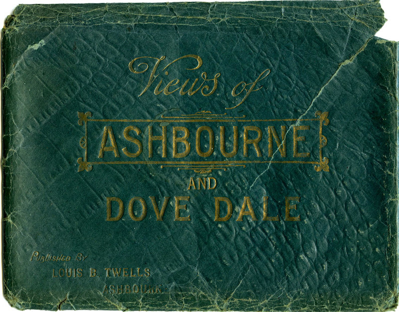
Views of Ashbourne and Dove Dale
Published by Louis B. Twells, Ashbourne

This time I can use a couple of more recent acquisitions, purchased for very modest sums on eBay. The first, a large envelope made of green paper with a shiny, faux crocodile skin finish and gold print, contains 32 black-and-white and blue-tinted lithographic prints, each measuring approximately 205 x 151mm (8" x 6"). The title on the envelope simply states, "Views of Ashbourne and Dove Dale" - which indeed they are - published by Louis B. Twells of Ashbourne.

Louis Bosworth Twells (1829-1885) settled in Ashbourne (Derbyshire) around 1855, and over the next three decades conducted a variety of trades: hair cutter/dresser, perfumer, jeweller, silversmith, watch maker, importer of general fancy goods, sponges, &c., and proprietor of "large show rooms for glass, china, and earthenware." I have seen a single example of a carte de visite portrait which he also "published." There is no direct evidence that he took any photographs himself, but he may well have done. After his death in 1885 his widow and son, also named Louis B. Twells, continued to operate the business until 1903.


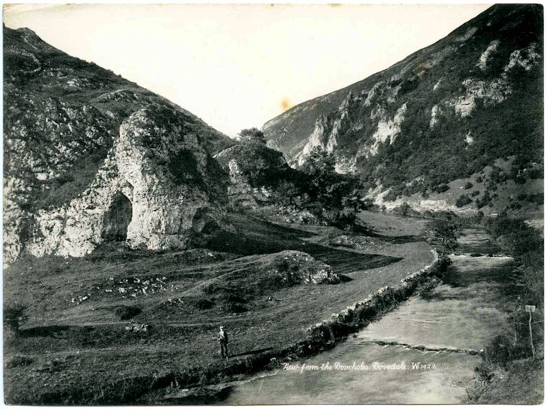
View from the Doveholes, Dovedale (Ref. W. 1424)
Original photograph publ. by James Valentine & Co.
Lithographic print publ. by Louis B. Twells, Ashbourne

This view of Dovedale from the mouth of the limestone cave known as Dove Holes is one of 16 prints of excellent quality which don't carry the name of either photographer or publisher. A detailed examination of the prints reveals artefacts suggesting that they were reproduced from carefully retouched photographic prints.


After some deliberation I've decided that the text so carefully pencilled out in this image included a negative number and the original publisher's initials:

1424 JV + Co. Ltd
in the characteristic cursive script used by famous postcard publisher James Valentine & Co. of Dundee. However, I've yet to find an example of the original photograph published by Valentine.


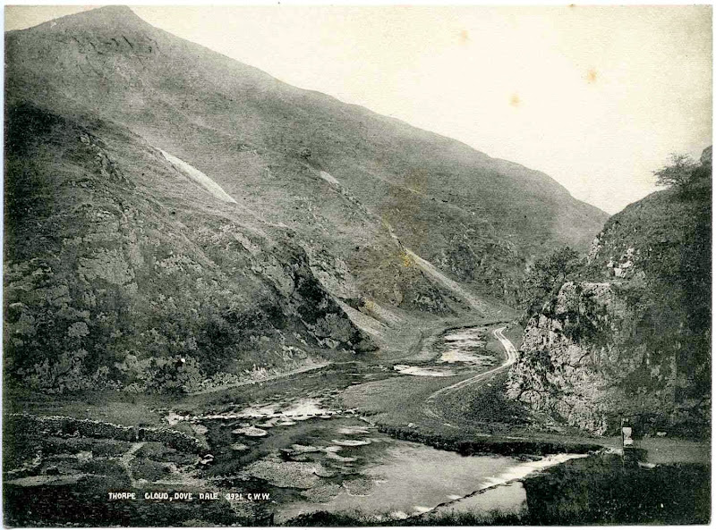
Thorpe Cloud, Dovedale (Ref. 3921)
Original photograph publ. by George Washington Wilson

A second group of 16 prints show similar landscapes. Although of slightly poorer reproduction quality, these views are still very professionally composed, and are annotated with the initials "G.W.W." This indicates that they were originally published by George Washington Wilson & Co. of Aberdeen, another Scottish photographer who became one of the largest publishers of photographic prints in the world, rivalling the business of Valentine and Sons.

Image © and courtesy of University of Aberdeen Library, Special Collections and Museums
In Dovedale Looking Up Entrance to Dale, (Ref. 3923)
Glass plate negative 220 x 170mm by G.W. Wilson & Co. of Aberdeen
Image © and courtesy of University of Aberdeen Library, Special Collections and Museums

The University of Aberdeen Library has an enormous collection of 45,000 of George Washington Wilson's glass plate negatives, the original photographs taken between 1853 and 1908, with digitized images online. There are 488 views of Derbyshire alone and the web site is well worth a visit. I wasn't able to find the same view, but I did find a similar one, with a negative number (3923) suggesting that it was probably taken on the same occasion.


Views of Ashbourne and Dovedale
Images © and collection of Brett Payne

The remaining views from the Ashbourne & Dovedale collection can be seen in this slideshow created with Picasa. It's difficult to know now if all 32 of the prints were originally sold in this wallet, or whether the G.W. Wilson prints were added later by a previous owner. However, from what I can tell, they appear to have been taken over roughly a decade from the mid-1880s through to the mid-1890s. Photographs mounted on glossy card of the particular shade of dark green used for the envelope were very popular in the 1890s, and I suspect that Louis Twells Junior was selling this collection at this time.

Images © and collection of Brett Payne
Unidentified group at Twelve Apostles' Rock, Dovedale, c.1900-1910
Lantern slide (83 x 83mm) by unknown photographer
Images © and collection of Brett Payne

My other purchase was a small group of lantern slides, almost certainly taken by an amateur, two of which depict an outdoor excursion by a small group of young men and women. Although not annotated, the view above is identifiable as the River Dove in the vicinity of Twelve Apostles' Rock, also shown in one of the prints by G.W. Wilson in the slideshow above.

Images © and collection of Brett Payne
Unidentified group, probably at Dovedale, c.1900-1910
Lantern slide (83 x 83mm) by unknown photographer
Images © and collection of Brett Payne

A second image shows three men and four women seated on a hillside, judging by the nature of the scree, probably the lower slopes of Thorpe Cloud or one of the adjacent hills flanking the entrance to Dovedale. If, as seems likely, the group consisted of four young couples, a fourth man is probably taking the photograph. One of the other slides in this small collection is dated 1906, and the clothing fashions of the women in the photo suggest that these are from a similar time period.

Image © and courtesy of the Tauranga Heritage Collection
Magic Lantern Projector
Image © and courtesy of the Tauranga Heritage Collection

The second half of the nineteenth century saw a huge expansion in the number of people taking trips to the seaside and day excursions into the country. Pictorial mementos available to the everyday tourist included scenic images in the form of stereoscopic cards, carte de visites and unmounted prints published by both local firms and by larger enterprises such as Valentines and G.W. Wilson.

During the 1890s and early twentieth century advances in camera design and technology made them considerably cheaper and more portable. As a result, excursionists were able to create their own mementos as they enjoyed their holiday. These lantern slides were most likely produced by direct printing on thin glass slides from original glass-plate negatives, and would have been displayed with a magic lantern projector similar to that shown above.

References

Postcard Publishers, Printers, and Distributors of Note by the Metropolitan Postcard Club of New York City.

The George Washington Wilson and Co. Photographic Collection, University of Aberdeen Photographic Archive.

George Washington Wilson Collection online.

Friday, 30 October 2009

Digging for gold on the wild West Coast

Nola Sinclair recently sent me scans of a couple of engaging cartes de visite by H.H. Vorley of Westport, Charleston and Reefton, on the West Coast of New Zealand, who I have featured in a previous Photo-Sleuth article. She explained that "the subjects in the photo are likely to be a family of my husband's Shetland Island forebears who came to Charleston in 1876 to mine the sands at Nine Mile Beach for gold. We have been trying to get a fairly exact date so we can work out who the children are likely to be, in order to make sure that it is indeed the family we think it is."

This challenge required some considerable background reading on my part, but the subject is of particular interest to me. Not only was I involved in the gold exploration industry for some fifteen years, but I've long had a fascination with historic gold rushes and the motley cast of characters who often played a part in them, such as the Californian forty-niners (1849), the Witwatersrand uitlanders (1886) and the Klondike stampeders (1897).

Image © and courtesy of National Gallery of Australia
Darran Mountains & Bowen Falls, Milford Sound, 1888
Print by Burton Brothers, Dunedin
Image © and courtesy of National Gallery of Australia
Accn No: NGA 2007.81.119AB

Prior to the 1860s the West Coast of New Zealand's South Island was an almost completely uninhabited no-man's land, the steep forest-encrusted and almost inpenetrable slopes and rocky, surf-pounded coasts with few natural harbours discouraging all but a few passing explorers. Maori visitors, who succeeded in extracting prized pounamu from the river valleys and mountain peaks, and pakeha whalers briefly occupied a few temporary shore stations, but neither group left much in the way of permanent settlements. District boundaries tended to be merely lines drawn on the maps by the colonial state authorities with little real meaning on the ground. In 1861 Charles Hursthouse described it as "a savage, gloomy country, silent, desolate and dreary ... this vast tract is unpeopled; millions of acres have never been trodden by human foot ... fresh from nature's rudest mint, untouched by hand of man.," but then went on to predict with pinpoint accuracy the forthcoming means of change: "... this part ... has as yet been very partially explored ... [but] may prove to be New Zealand's 'Gold Coast'." [1]

Image © and courtesy of State Library of Victoria
Wallace's Point, Otira Gorge, Canterbury, 12 June 1876
Wood engraving published in The Illustrated Australian News
Image © and courtesy of State Library of Victoria
Accession no IAN10/07/76/104

Between 1865 and 1867 a sequence of events shattered this isolation forever. In the early 1860s the province of Otago, situated on the other side of the Southern Alps, had experienced a gold rush the likes of which had never before been seen in New Zealand. As individual diggings like Gabriel's Gully suffered declining yields of the royal metal, prospectors looked further afield towards the West Coast, walking overland through the dripping, verdant forests and exploring by boat the shingle beaches and rivers along the wild, rocky coast. [2]

Charleston and Constant Bay, c.1880s (Dyson Album)
Albumen print, 120 x 200 mm, on album page
Image © Alexander Turnbull Library and courtesy of Timeframes
Reference No. PA1-q-069-02-1

On the 27th February 1865 the landing in Nelson of an single enormous shipment of gold from diggings at Hokitika, equal to the entire production from the previous year, precipitated a tremendous rush. Within a matter of weeks word had spread, not only to Wellington, across the Cook Strait, and more distant provinces such as Canterbury and Otago, but also across the Tasman to Victoria and New South Wales. Diggers braved the wild seas, cramming every available sea-going vessel, and travelled to the new finds by any means they could find. Settlements began to spring up in the Waimea Valley, Okarito, Greymouth and the Pakihi, between the Buller and Grey Rivers. [3]

Image © Alexander Turnbull Library and courtesy of Timeframes
Hotels & shops on Princes Street, Charleston, c.1869
Image © Alexander Turnbull Library and courtesy of Timeframes
Reference No. 1/2-055911-F

Almost overnight clusters of scruffy tents mushroomed into bustling towns with narrow streets, elaborate wooden buildings, hotels and dancing girls. [4] Perhaps the greatest of these in the history of the West Coast was the Charleston rush, reaching a peak between 1867 and 1870 with a population of around 5,000. [5] Boats bringing in both prospectors and supplies braved the narrow and treacherous entrance to the tiny Constant Bay, with wrecks and tragedy a common occurrence. [6]

Image © and collection of Brett Payne
Carte de visite card mount used by H.H. Vorley, c.1870-1872
Charleston, West Coast, New Zealand
Image © and collection of Brett Payne

One of the many hundreds of people who set up shop in Charleston to take advantage of the tremendous increase in trade was photographer Herbert H. Vorley. [7] Although born to a wealthy merchant family in London he emigrated to New Zealand in the mid-1860s, arriving on the West Coast and setting up as a photographer and phrenologist in the town of Westport prior to 1867. While maintaining this studio, he is also known to have operated branch studios in Charleston (1867, 1869, 1873 & 1875), Hokitika (1870), Buller (1874 & 1877) and Reefton (1877-78). [8]

Image © National Library of New Zealand and courtesy Papers Past
Advertisement from the Inangahua Times, 15 May 1878
Image © National Library of New Zealand and courtesy of Papers Past

It seems likely from the nature of advertisements in the Grey River Argus, the West Coast Times and the Inangahua Times between 1875 and 1878 that the branch studios were open only intermittently, and on occasion staffed by managers or employees. A detailed examination of back issues of the Charleston Herald - sadly not yet included in Papers Past, the National Library of New Zealand's otherwise comprehensive digital coverage of old newspapers - may be they key to determining more precisely the dates of Vorley's presence in Charleston. [9] An inheritance received after the death of an English aunt in January 1879 enabled Vorley and his family to leave Westport in May that year and return to England, where he died a year later. [10]

Image © USC Regional History Center, CHS/TICOR Collection and courtesy of the History Computerization Project
A gold prospector tries his luck, California, undated
Image © University if Southern California Regional History Center, CHS/TICOR Collection and courtesy of the History Computerization Project

The gold output of the Charleston area, in tune with the "boom and bust" cycles experienced in all of the other gold fields, was already waning by the early 1870s and the population dwindled rapidly, with many leaving to try their luck in newer fields such as Thames on the North Island. [3] Other enterprising diggers remained in the area and a large and well documented group of Scots from the Shetland Islands turned their hand to washing gold at Nine-Mile Beach, a short distance north of Charleston. Although the alluvial beach deposits had been discovered and worked by other beachcombers using fairly primitive methods a few years earlier, the first of the Shetlanders to arrive, in January 1870, were Magnus Mouat and Gilbert Harper from the village of Norwick on the northernmost island of Unst. [11]

Image © and courtesy of the Wellington Shetland Society
Shetlanders' settlement at Nine-Mile Beach, 1886
Lantern Slide
from Chips of the Auld Rock publ. 1997
Image © and courtesy of Wellington Shetland Society

Having spent a couple of years wandering the Queensland, New South Wales and Bathurst gold fields and eight months at Bradshaw's Creek near the Buller River with little to show for their efforts, the auriferous black sands at the southern end of Nine-Mile Beach appeared to offer more promise. [11] So much, it appears, that sent word to other members of the original Unst party who had wandered elsewhere in Melbourne and Otago, and wrote to friends and family back home in Unst.

Image © Mike Pennington and courtesy of Geograph.co.uk
The village of Norwick in August, Unst, Shetland Islands
© Copyright Mike Pennington, courtesy of Geograph.co.uk
& licensed for reuse under this Creative Commons Licence

A dwindling of traditional fishing and farming opportunities, as well as clearances in the Shetlands, coincided with timely offers of assisted passage from Sir Julius Vogel's recruitment drives and immigration schemes. [12] Over the next few years a large number of families joined them, such that by 1877 it was estimated that there were about a hundred Unstmen working the sands at Nine-Mile. In November 1875, the provincial government surveyor was kept very busy surveying new leases and extended claims on Nine Mile Beach. [13] Magnus Mouat himself went home for a couple of years, during which time he married, returning to the West Coast goldfields with wife and baby aboard the Howrah in November 1876. [14]

Image © Alexander Turnbull Library and courtesy of Timeframes
Shetlanders beachcombing blacksand for gold, Nine Mile Beach, c. late 1870s
(L-R) Magnus Johnson, John Madden, James Mouat, J.R. Mouat, Gilbert Harper & James Harper
Image © Alexander Turnbull Library and courtesy of Timeframes
Reference number: PAColl-6181-35

The Shetlanders were strong, practical men and soon improved their chances by purchasing most of the claims on Nine-Mile Beach and by developing new methods of extracting fine gold from the layers of black beach sands. Apart from the building of extensive tail races or flumes by Messrs. Hall, Parsons and Harle to bring to the beach the water so essential to the operation, already well under way by March 1872 [15][16], the Shetlanders made significant improvements to the washing process, designing the multi-tier mobile washing tables, or "beach boxes." These devices are illustrated in the images above and below, while the tail races are clearly visible in the background of the lower image.

Image © Alexander Turnbull Library and courtesy of Timeframes
Blacksanding at Nine-Mile Beach, undated
William Harper (left) and John Mouat (right)
Image © Alexander Turnbull Library and courtesy of Timeframes
Reference number: 1/2-015698-F

The Charleston Herald (reported in the Grey River Argus) remarked on their good fortune although it was, no doubt, mixed in with decent proportion of hard slog:
1 December 1876
The beach claims in Second Bay and on the Nile and Nine-mile Beach, have for the past five or six months been paying exceedingly well. The men on Nine-mile Beach have been very fortunate, they having during the above-mentioned term been earning on an average from 25s. to 30s. per day.

6 July 1878
since the late stormy weather, accompanied by heavy south-west gales, the Nine-Mile Beach claims are paying splendidly, some of the miners who work long hours netting as much as £12 per man per week. It is said, and with a good deal of truth, that the mining property, dams included, sold some six years ago by Mr Fred Hall for the sum of four or five hundred pounds, to-day is worth as many thousands. This tells well in favour of the healthy condition of mining matters in this district.

13 August 1878
One of the beach claims which was only the other day taken upon the Nine-mile Beach, on the Northern limit, having hitherto being lying idle, was sold last week by Mr Thomas Humphries to Mr Sullivan for the sum of £50. At present there are more beachcombers at work on the Nine-mile Beach than has been remembered for the last six or seven years, and the lowest wages made by them is £3 and £4 per week, the highest being £10 and £12. The beach has "made" so much that the men are sure that payable ground exists to within close limits to the Totara river - a distance from the north claim, now work of about two miles. At present the water is not conveyed any distance along the beach, so that there is little probability of the ground now lying dormant being worked just yet, though we hear that it would be a very easy matter to bring water to the ground.
Image © and courtesy of Nola Sinclair
Group of men, women & children in front of house, c. 1876-1879
Carte de visite by H.H. Vorley of Westport, Charleston & Reefton
Image © and courtesy of Nola Sinclair

Nola Sinclair's husband's ancestor James Mouat Harper (1832-1918) arrived with his wife Margaret (née Anderson) (1836-1918) and eight children [17] in Nelson in January 1876, after a three month trip from Unst. They were part of a large group aboard the Caroline making their way to Charleston where a great Unst reunion was subsequently held. [11] The carte de visite portrait shown above depicts a large group of nine men, women and children standing in front of a wooden building, with a backdrop of moderate sized trees. The house has a cylindrical water tank, apparently for collecting water off the roof via the visible gutters and down-pipes, and a timber(and corrugated iron?)-encased chimney to the left. There is also a wood picket fence in the right foreground, possibly enclosing a vegetable garden.

Image © and courtesy of Joan Robertson
Group of 9 men, women & children in front of house, c. 1876-1879
Carte de visite by H.H. Vorley of Westport, Charleston & Reefton
Image © and courtesy of Joan Robertson

Nola also sent me this image of another carte de visite, which she had received from Joan Robertson, a distant cousin of her husband's still living in the Shetlands. It is very similar, although not identical, to the one that Nola has in her collection.

Image © and courtesy of Nola Sinclair and Joan Robertson
Group of 10/11 men, women & children in front of house, c. 1876-1879
Detail of carte de visites by H.H. Vorley
Image © and courtesy of Nola Sinclair

A comparison of detailed scans elucidates some differences: most of the figures have moved slightly, and in the second shot there is an additional male adult figure standing immediately to the right of the doorway. The only adult female is standing at the extreme left of the group. The youngest of the children, standing at second from left, is perhaps three or four years old; the clothes suggest a little girl - although one cannot be certain at this young age - who is holding his or her mother's hand. The figure to the right of this is almost certainly a boy, wearing a cap and long trousers, and probably five or six years old. Next are two girls, aged about 8-9 and 10-11, respectively. To the right of the doorway a further group of three girls are fairly similar to each in height - almost the height of the adult woman at extreme left - so it is difficult to estimate their ages beyond saying that they are probably in their mid- to late teens. They all have their hair in a style typical of the 1870s, partly in plaits tied up in a circlet on the crown, and partly descending in ringlets to the shoulders at the back.

All three men are bearded and wearing hats. I would suggest that the man to the left of the doorway, wearing a waistcoat, is older while the two to the right are somewhat younger, but it is difficult to be precise. The men to the left and right are wearing bowler hats, of a style with a moderately high brow which was common through the 1870s and early 1880s. The man in the middle has what appears to be a forerunner of the wider flat-brimmed slouch hat, and is wearing a jacket.

The reverse of the second carte de visite (shown below) is inscribed, in what appears to be a contemporary hand, "to Anthony." Nola tells me that the second photograph was a copy mailed back home to Anthony Anderson, great grandfather of Joan Robertson, possibly by Anthony's sister Margaret Yule Harper.

Image © and courtesy of Nola Sinclair
Detail of carte de visite by H.H. Vorley
Image © and courtesy of Nola Sinclair

If this is the case, then she may have been the woman standing at the extreme left of the group, and the remaining figures would then include her husband James Harper and at least some of their children. She is dressed in clothes typical of of the mid- to late 1870s. The bodice is tight-fitting with a prominent vertical row of buttons, and a bow at her neck, while the sleeves are narrow, a little looser at the wrist, and possibly with a frilled or pleated cuff. Although not actually visible, the bustle in her skirt is probably small, if present at all, and the skirt contains several layers, types of fabric or ornamentation. Her hair is parted in the centre drawn back tightly, probably into a bun at the back of her head.

Two further children were born to James and Margaret after their arrival in New Zealand, bringing the total to ten [17]:
James Mouat HARPER (1832-1918) m: 1855 Margaret Yule ANDERSON (1836-1918)
- Charlotte b. 24 Jan 1857 Norwick, Unst
- William b. 29 May 1859 Norwick, Unst
- Elizabeth b. 15 Feb 1862 Braefield, Norwick, Unst
- Williamina/Wilhelmina b. 23 Aug 1864 Unst
- Margaret b. 23 Jun 1867 Velzie, Unst
- Jemima b. 16 Apr 1870 Unst, Unst
- Gilbert b. 3 Mar 1873 Velzie, Unst
- Ann b. 3 Jul 1875 Norwick, Unst
- Isabella b. 7 Jan 1879 Charleston, New Zealand
- Anthony b. 24 Dec 1881 Charleston, New Zealand

Image © and courtesy of Joan Robertson
Reverse of Carte de visite by H.H. Vorley of Westport, Charleston & Reefton
Image © and courtesy of Joan Robertson

The reverse of both card mounts have a design very similar to that of the Vorley carte de visite shown earlier, with the addition of studio locations in Charleston and Reefton, suggesting to me a slightly later date i.e. some time after c. 1870-72. We can be fairly sure, however, that the photographs were taken prior to May 1879, when Vorley left New Zealand for good. This rules out the possibility of the youngest child born to James and Margaret in New Zealand being in the photograph, since Anthony was born in December 1881. If height is used as an approximate indication of age, then the children in the photograph are arranged from left to right in increasing order of age.

Image © and courtesy of Nola Sinclair

Detail of carte de visite by H.H. Vorley
Image © and courtesy of Nola Sinclair

Now some theorising. If - and I agree with Nola that we should emphasize the 'if' - this were to be the Harper family, then the only young male child, aged approximately five in the photograph, must be Gilbert Harper, born in Unst on 3 March 1873, suggesting a possible date for the group portrait of 1878 or early 1879. How do the the ages of the remaining children and adults in the group fit with what we know about the Harper family? Well, I think they match very nicely. N.B. The numbers in the provisional list below refer to those shown in the silhouette index above.

1. Margaret Yule Harper née Anderson, aged 42ish - Margaret does not appear very pregnant in this photograph, and since she had her ninth child Isabella in January 1879, I suggest this is unlikely to have been taken in late 1878. It is conceivable, however, that it was taken after the birth of Isabella, and that the baby is asleep indoors.
2. Ann Harper, aged 3
3. Gilbert Harper, aged 5 - Gilbert died at Charleston on 14 March 1883, aged 10.
4. Jemima Harper, aged 8
5. Margaret Harper, aged 11 - although the top of Margaret's head is only slightly higher than that of Jemima, examination of her feet shows that she is standing in a slight dip, and is therefore somewhat taller than she appears in relation to her next youngest sister.
6. James Mouat Harper, aged 45 - James Harper's central position in the group and manner of standing with his feet slightly apart, hands crossed calmly and patiently in front of him, is commensurate with his status as head of the household.
7. This is probably a younger man, although the full beard does disguise the age to some extent. His is a youthful figure assuming a very relaxed pose, his legs crossed, leaning against the door jamb with his thumbs tucked into his belt, holding the flaps of his jacket open. The jacket may have fringe sleeves, in a "Western style." This is most likely to be William Harper, who would have been aged 19, and very much "at home."
8. Williamina Harper, aged 13 or 14
9 & 10. Elizabeth Harper, aged 16, and Charlotte Harper, aged 21
11. This man, perhaps a little older than the man postulated as William Harper, is standing well off to the right hand side of the others. With his elbow perched on the window sill and right hand to his cheek, he is facing and leans in towards the rest of the group, in contrast to all of the others, who look directly at the photographer and his camera. So, while he is clearly part of the group, one gets the feeling that he is somehow distanced from it, in both a physical and more social sense. The eldest Harper daughter Charlotte married James Harper Mouat (1849-1928) at Charleston on 3 May 1878, and my feeling is that this is young Mr Mouat. He would have been about 30 years old at the time, and the photograph may have been taken before the wedding - hence the distance between him and the Harpers. [17]

Image © and courtesy of the Wellington Shetland Society
Detail of Shetlanders' settlement at Nine-Mile Beach, 1886
Lantern Slide
from Chips of the Auld Block publ. 1997
Image © and courtesy of Wellington Shetland Society

The house forming the backdrop in this group portrait looks very similar in shape and form to the second building along the beach in the 1886 view, as pictured in the detailed image above, although Nola has pointed out that the frieze of large trees behind the house has been removed.

So ... we can make several tentative conclusions:

(a) The carte de visite portrait was most likely taken between 1874 and 1879 at or near Westport, Charleston or Reefton on the West Coast of New Zealand.

(b) We have a possible identification of the house in the portrait as being one of those built by the Shetland community prior to 1886 on Nine-Mile Beach.

(c) The group shown matches very closely the Harper family that we expect to have been living at Nine-Mile Beach in 1878.

Although I feel we have a probable identification, to be more confident I would suggest examining the make up of the other Shetland families who were living at Nine-Mile Beach in the late 1870s, to see if any of them fit the pattern. Most of the families living there were fairly closely related, having emigrated from the same small district on the island of Unst, so it is conceivable that somebody else might have sent a copy home "to Anthony."

Image © Alexander Turnbull Library and courtesy of Matapihi - National Library of New Zealand
Powell's sluicing and elevating claim at Nine Mile Beach, c.1900
Image © Alexander Turnbull Library Ref. PAColl-6075-51
Courtesy of Matapihi - Alexander Turnbull Library, New Zealand

In the mid-1880s there were still between 70 and 80 Shetlanders working the sands at Nine-Mile Beach but eventually the deposits were depleted and by the turn of the century, when the above photograph was taken, the numbers had declined considerably. [14] In 1906 there were only 15, and the last of the original pioneer Shetlanders, William Harper, moved away in 1916. [11]

Acknowledgements

I would like to thank Nola Sinclair and her husband for the opportunity to use her photograph as the subject of this article, and the Alexander Turnbull Library for permission to use scanned images of photographs in their collections.

References

[1] Hursthouse, Charles (1861) New Zealand, The "Britain of the South." 2nd Edition. London: Edward Stanford. p. 149. [Available online from Google Books]

[2] May, Philip Ross (1962) The West Coast Gold Rushes. Christchurch: Pegasus. 55p.

[3] Eldred-Grigg, Stevan (2008) Diggers, Hatters & Whores: The Story of the New Zealand Gold Rushes. Auckland: Random House New Zealand. 543p. ISBN 9781869419257

[4] Wood, Frederick Lloyd Whitfield (1971) Understanding New Zealand. Ayer Publishing. 267p. [Partially available on Google Books]

[5] Charleston, New Zealand. Wikipedia article.

[6] Wall, Ella & Lewers, Neville R. (ill.) (1939) Gold Rush at Charleston. Adventure - In the Old West Coast Days. in The New Zealand Railways Magazine, Volume 14, Issue 6 (September 1939) [Available online courtesy of the New Zealand Electronic Text Centre (NZETC)]

[7] Payne, Brett (2008) Fraternal Organisations. Photo-Sleuth, 3 August 2008.

[8] Anon (n.d.) Vorley, Herbert Henry. Auckland City Libraries Photographers Database.

[9] Extracts from Grey River Argus, West Coast Times, Nelson Evening Mail, Inangahua Times & Evening Post. Papers Past, Digital images of New Zealand newspapers and periodicals, from the National Library of New Zealand.

[10] Rackstraw, Tony (2008) Vorley, Herbert Henry. Early Canterbury Photographers, including South Canterbury and the West Coast, 22 August 2008.

[11] Faris, Irwin (1941) Charleston : its Rise and Decline. Wellington : A. H. and A. W. Reed. Reprinted 1980 by Capper Press, Ltd. [Extract courtesy of Nola Sinclair]

[12] Scots - The Late 1800s. Te Ara Encyclopedia of New Zealand.

[13] Grey River Argus, Volume XVI, Issue 2259, 4 November 1875, Page 2. Papers Past.

[14] Butterworth, Susan M. & Butterworth, Graham (1997) Chips off the Auld Rock: Shetlanders in New Zealand. Wellington: Shetland Society of Wellington. 251 p. [Extract courtesy of Nola Sinclair]

[15] Grey River Argus, Volume XII, Issue 1142, 26 March 1872, Page 2. Papers Past.

[16] Grey River Argus, Volume XII, Issue 1337, 11 November 1872, Page 2. Papers Past.

[17] The Family of James Mouat Harper & Margaret Yule Anderson, on the Shetland Family History Home Page.
Monday, 19 October 2009

Have space suit - Will travel

Almost a year ago I posted this image of a rather bizarre transportation device in an article on Photo-Sleuth in the hope that readers would be able to help solve the mystery of what exactly it was, and why it appears in my aunt's collection of old family photographs. The footnoteMaven's 18th Smile for the Camera Carnival has the theme of "Travel" and seems an opportune moment to revisit the subject, summarizing what I've learnt.

Image © and courtesy of Barbara Ellison
Transport contraption, St Malo, France
Carte de visite by unknown photographer
Image © and courtesy of Barbara Ellison

The carte de visite is part of the Payne family heritage, held by my aunt, which I scanned on a visit to England a couple of years ago. There is no background to it at all, except that it probably came from the collection of my great-grandfather Charles Vincent Payne (1868-1941). The photograph shows some kind of viewing platform on which at least two dozen people are crowded, itself mounted on stilts or a tower standing in water. Ripples in the water around the base of the legs suggest some movement, either of the water, or of the contraption itself. It is apparently located in a bay, as a shoreline with buildings is vaguely visible in the background.

© Ed Emshwiller and courtesy of Wikipedia
Have Space Suit, Will Travel by Robert A. Heinlein,
1958 hardcover edition illustration by Ed Emshwiller,
published by Charles Scribner & Sons, New York

The contraption is a little too rectangular - and authentic - to be one of H.G. Wells' War of the Worlds tripods, but it does seem almost in the genre of science fiction, or what passed as science fiction in the Victorian era. Hence my somewhat off-the-wall visualization of the theme of Robert Heinlein's 1958 book which lends its title to this article.

Image © and courtesy of Barbara Ellison

There are some further clues to the moving tower. Handwritten in purple ink on the front and reverse of the card mount is the following text:
Passes between St Malo & ...
It goes by
Machinery
I passed over it last year
& again this year twice
Aug 1882
It takes about 3 minutes
to cross, its only 1 sous
By comparison with handwriting that I know to be that of Charles Vincent's father Henry Payne (1842-1907) - from an 1891 letter, reproduced in a previous Photo-Sleuth article - I believe this must be the hand of Henry. If he did indeed travel from his home town of Derby in the English Midlands to France a couple of times in the early 1880s, Henry must have been a pretty well travelled - and busy - man. In 1880 Henry, his wife Henrietta and children made a short-lived attempt to settle in America, spending a few months farming at Bladensburg, Maryland before returning to England late that year or in early 1881.

What was Henry doing abroad again so soon? Nigel Aspdin has suggested in a comment to the previous article that he may have used a separate and more circuitous route back from the United States, rather than the more direct Baltimore-Liverpool run which the rest of the family presumably took. He also postulates that wrapping up the farming business venture in North America may have required another trip, and it was easier, quicker or cheaper to "take a train Derby-Portsmouth, a ferry across to St Malo, and catch a ship in France, say Le Havre, St Nazaire, Cherbourg or maybe St Malo itself." All of these possibilities are worth thinking about and investigating in further detail some time, but I will resist getting too sidetracked for the duration of compiling this article.

Nigel also remarks on the sous (or should that be "sou") apparently still being used as the colloquial price for a fare, almost a century after the official currency had changed from livres/sous/deniers to francs/centimes. Another diversion which I shan't pursue for the moment, although still of interest.

Image © and courtesy of the Melbourne Meccano Club Inc.
Meccano model of the St Malo Transporter Bridge, Brittany
Image © and courtesy of the Melbourne Meccano Club Inc.

Nigel again provided the vital clue to the real nature of what I had referred to as a possible tourist trap with the key search words, "St Malo transporter bridge," which brought up a modern image of a Meccano model made by a hobbyist to a design from the May-June edition of Meccano Magazine.

Image © and courtesy of
Part of front page of Meccano Magazine, Vol. 1, No. 9, May-June 1919.
Image © and courtesy of Rémi's Meccano Pages

I also found an original image of the design in the facsimile online Meccano Magazine hosted by Rémi's Meccano Pages, which includes in its caption: ... an excellent representation of the Rolling Bridge which conveys passengers from St. Malo to St. Servan.

Image courtesy of Wikipedia user Fibo.cdn
Côte d'Émeraude. 535. Saint-Malo - Le Pont Roulant à marée basse
Postcard published c.1900
Image courtesy of Wikipedia user Fibo.cdn

From this it was but a short step to several descriptions of the history and numerous images of what was more correctly termed the Pont Roulant of St. Malo. Two of the most informative are on the Tramway Information pages and in a Wikipedia article. The latter is in French, which I could conceivably have read (with some difficulty), but for which I more conveniently used Google's handy Translation Toolbar. The result is not too bad in terms of fluency, although as is common with most online translators, it produces an unintentionally amusing commentary on the workings of the unusual machinery:
The bridge was traveling on Vignoles rail 38 kg / m, whose spacing was 4.60 m. The truck was supported by wheels 1 m in diameter, which was placed before a stone-hunting.
The platform 7 mx 6 m, surrounded by a railing crossbar with benches in length, included a pool party where the passengers took shelter in bad weather.
The set of 14 tons was pulled by strings. A steam 10 c. was prepared in a wood shop located on the wharf. The driver of the platform indicated by the sudden departure of trumpet at machinist posted in this shop. The arrest was served by a second blow of the trumpet.
Image © John R.Prentice and courtesy of Tramway Information
1509. Côte d'Émeraude. 19. Saint-Malo-Saint-Servan - Le Pont-Roulant
Image © John R.Prentice and courtesy of Tramway Information

The Tramway Information article reveals that the Pont Roulant was constructed in 1873 by a local architect, Alexandre Leroyer, who held a concession to operate it for sixty years. It spanned the entrance to the French port of St Malo, which at low tide could be traversed along a stone causeway, and was designed to transport passengers between the towns of Saint-Malo and Saint-Servan. The original two-minute (or three, according to Henry) passage on the 13 metre-high rolling platform was made between two specially designed "docking stations," powered by a steam engine housed at the St.-Servan end, and carried up to two thousand people a day. Later, after the Leroyer's death the new concessionaire replaced the steam engine with electric motors. The centre of the platform had a covered cabin with glazed sides, affording panoramic views even under inclement weather conditions. Despite being seriously damaged by fire on one occasion in August 1909, and by collisions with ships in February 1889 and November 1922, it continued running until its eventual closure in November 1923.

L'Épopée du Pont Roulant de Saint-Malo à Saint-Servan, by Henri Fermin

The tourist attraction has also, I have discovered, been the subject of a book, L'Épopée du Pont Roulant de Saint-Malo à Saint-Servan, by Henri Fermin.


I even found a stereographic image of the Pont-Roulant, presumably from around the turn of the century ...

Image © and courtesy of Collecting House
Pont-Roulant, St. Malo, c.1890
Magic lantern slide
Image © and courtesy of Collecting House

... and a lantern slide from slightly earlier showing passengers alighting.


Côte d'Émeraude 226 - Saint-Malo - Le Pont Roulant
Postcard posted 1910

Judging by the number of extant used and unused postcards from the first couple of decades of the twentieth century, such as the example above posted in 1910, the ride continued to be a popular novelty with tourists right through to Edwardian times. I have noticed, however, that the postcard views rarely show as many customers aboard as Henry's carte de visite.

The final words I will leave to Phil Beard, who in his commentary on the visual arts and popular culture refers to the Pont-Roulant as Leroyer's "magnificent indifference to appearing ridiculous" and a product "of the Nineteenth Century imagination, notable for [its] impudent attempt to conquer time and space with the most slender resources." Perhaps so, but it succeeded in catching the tourists' imagination, and their sous.

18th Edition of the Smile for the Camera Carnival - Travel

References

St Malo Rolling Bridge from Tramway Information

Pont roulant de Saint-Malo from Wikipedia

Heilprin, A. & Heilprin, L. (1906) The Geographical Dictionary of the World. partially available online from Google Books.

Fermin, Henri (2005) L'Epopée du Pont Roulant de Saint-Malo à Saint-Servan, Nouvelles Impressions, ISBN 2951473508.

Le Pont Roulant by Phil Beard's Notes on the Visual Arts and Popular Culture
Join my blog network
on Facebook