Showing posts with label paintings. Show all posts

Saturday, 16 April 2011

Sepia Saturday 70: A boy and his toy

Image © and collection of Brett Payne

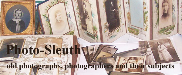
This boy's parents may have scrimped a little on Christmas presents by putting off buying him a new suit, but they spared nothing in acceding to his demands for the latest in locomotory accessories. I exaggerate a little, of course, since most of the several hundred Google images of "antique horse tricycles" are full-bodied models, close cousins to the fancy rocking horse featured in a previous Photo-Sleuth article, and far more elaborate than this pared down version. Judging by the number of horse tricycles that seem to have survived, they were not that uncommon. Sadly, the identity of the proud young lad, caught in the moment before he escapes down the driveway to show it off to his friends, is unknown.

Image © and collection of Brett Payne

The photographer's name, on the other hand, is clearly displayed on both the front and reverse of the card mount. By the time he took this photograph, perhaps in the mid- to late 1880s, Frederick William Broadhead (c1846-1925) was a well established Leicester photographer, although the bulk of his commissions were conventional studio-based portraits, rather than outdoors shots. This example was clearly taken outdoors, but whether outside the studio premises or in the boy's own garden is unknown. It is perhaps a useful reminder that we should always examine the background to such outdoors photographs in our family collections for clues as to their location.

Image © and courtesy of Christies
"View of Castle Cornet St Peters Port Guernsey Taken from the Hights" by F.D. Broadhead, oil on panel, c.1870
Image © and courtesy of Christies

Broadhead's father Frederick Dodson Broadhead (c1812-1878) was a portrait and landscape artist, and the son also occasionally advertised as an artist. Although he was born in Kennington in London, Frederick William's family moved frequently, so that by the time he started work aged 14 as a lithographer in Litchurch, Derby, they had already lived in London, Bath and Nottingham, where his father presumably found commissions.

The Broadhead family moved again in the late 1860s to Leicester. Frederick junior was working as a photographer by November 1869, when he announced his removal to "more convenient premises [at] 14 Welford road." Cartes de visite were advertised from 6s per dozen, and portraits in oil from one guinea upwards. It is not clear whether the portraits were photographs finished in oils or miniature oil paintings, although I suspect the latter, as an article in the Leicester Chronicle in 1876 reported his having painted "a pair of life-size bust portraits of Mr. and Mrs. Thornton."

According to a newspaper article in 1879, F.W. Broadhead was one of the early practitioners in the use of artificial light in studio photography.

Leicester Chronicle & Leicestershire Mercury, 11 January 1879.
Night Photography.
Mr. Broadhead, of 65 Welford road, has secured a patent luxograph, by means of which portraits can be taken at night, and by which daylight and the sun's rays are not rendered indispensable accessories to the production of a good picture. The process is apparently very simple; the principle upon which it is worked being the concentration of the rays emitted from a series of carefully arranged reflectors directly upon the sitter. The light is produced by the ignition of chemical powders, and is of pale blue colour. Although for an instant its brilliancy is rather dazzling, it softens down into a soft mellow hue, void of all garishness, and rather pleasant to the eyes than otherwise. By this artificial means a portrait can be taken in from seven to twqelve seconds, and even this period is decreased to about five seconds when it has to be taken on a ferrotype plate. At present there are only two or three machines in use throughout the kingdom, but when its properties are well known they cannot fail to be highly appreciated.

Image © University of Leicester and courtesy of Historical Directories
Barker & Co.'s Directory for Leicestershire & Rutland, 1875

Trade directories, census, Royal Photographic Society registrations, newspaper entries and advertisements provide a detailed record of his studio addresses during the thirty years he was in business:

1869: 84 Humberstone Rd
Nov 1870-1875: 74 Welford Rd
1876-1877: 72 & 74 Welford Rd
1877-1885: 65 Welford Rd
1884-1892: 55 Welford Rd
1888: 24 Gallowtree Gate
1892: 44 London Rd
1895-1896: Stanley Chambers, 30 Gallowtree Gate
1898: Stockdale Terrace, 19 London Road
1900: 55 Chestnut St & 102 Welford Rd

Image © and collection of Brett Payne

Directory entries and designs on the reverse of his card mounts demonstrate that he also operated periodically in the nearby towns of Loughborough and Market Harborough, although the evidence for his presence in these places is more patchy. It appears that he may merely have visited periodically, as an 1883 trade directory entry indicates weekly attendance:

Broadhead Fdk. Wm., artist and photographer, High street (attend Tu.), Market Harborough

Image © University of Leicester and courtesy of Historical Directories
Leicester Chronicle & Leicestershire Mercury, 10 June 1882

In addition to opportunistic shots of Royal processions and general views of the town and local tourist spots, Broadhead was not averse to seeking other photographic commissions away from his studio premises:

Leicester Chronicle & Leicestershire Mercury, 16 August 1879.
The Leicestershire Volunteers in Camp ... at Willesley Park ... Mr. F.W. Broadhead, Welford-road, Leicester, camped out with the volunteers all the week, and took a great variety of views of the camp, and of the men when on parade, by an instantaneous process, and he appeared to do a "roaring" trade under his "special appointment as a photographer to the camp.

Image © University of Leicester and courtesy of Historical Directories
Wright's Directory of Leicestershire, 1887-88

Leicester Chronicle & Leicestershire Mercury, 8 July 1882.
The Australian Cricketers. Mr. F.W. Broadhead, photographer, of Welford-road, has produced a pair of excellent group portraits of the Australian and Leicestershire teams who took part in the match lately played on the Aylestone-road Ground. The work has been carefully executed in variou-sized photographs, and give a life-like representation of the players ... No doubt a large number of these photographs well be secured in commemmoration of Leicestershire having played so well against the antipodeans.

He also gave evidence regarding photographic matters to the Leicester courts on several occasions.

Leicester Chronicle & Leicestershire Mercury, 12 April 1884.
Charge against a photographer ... according to the evidence of Mr. Broadhead, photographer, it was impossible for Daniels to have taken the photo from the condition of the camera and under the circumstances detailed by Mrs. Glover and the groom who attended prisoner. Mr Broadhead, however, admitted that the camera would take a negative, but it would not be passable .... Frederick William Broadhead, photographer, said that he had tested the lenses in question, and found that the lens produced perfectly fitted Professor Colton's apparatus.

Records of the Copyright Office, Stationers' Company:
Photograph of the Mayor & Council of Leicester, consisting of 50 persons including the Mayor". Copyright owner and author of work: Frederick William Broadhead, 35 Welford Road, Leicester. Form completed 12 November 1892. Registration stamp: 14 November 1892.

Image © University of Leicester and courtesy of Historical Directories
Wright's Directory of Leicestershire, 1889-90

In 1889 he celebrated his twentieth year in business. He appears to have retired not long after moving to Coalville a decade later. Frederick W. Broadhead died in 1925 at Farnham, Surrey, aged 78. He was married twice, and had two sons and two daughters with his first wife Sarah Ann Fisher, who died in 1898. His second wife Leah Reeves died in 1935.

This is my contribution to this week's Sepia Saturday. For more in a similar vein, head off there for a browse - I won't say quick, because you're likely to be there for a while!

References

Heathcote, B.V. & P.F. (1982) Leicester Photographic Studios in Victorian & Edwardian Times, Royal Photographic Society, The Photohistorian supplement.

Sunday, 13 March 2011

Colvile's Story, Part 3: Massacre at Te Ranga

In the previous instalment Major Colvile had been instructed to fortify a redoubt at Maketu. After some indeterminate skirmishes, detachments of the 43rd and 68th Regiments and the militia, assisted by the shelling of gunboats off the coast, had managed to drive the East Coast invaders southwards.

Image © and courtesy of the Alexander Turnbull Library
Burial Ground at Te Papa, Tauranga,
after the Battle of Gate Pa, April 1864 [29]

Meanwhile, back in Tauranga, General Cameron had his hands full with plans for the assault on Maori fortifications at Pukehinahina on the following day. The resulting debacle of the Battle of Gate Pa on 29th April with its horrific casualties, particularly among the elite 43rd Regiment who formed a significant part of the storming party, is covered in great detail elsewhere [30] and need not be repeated here since Colvile took no part in it. Probably as a direct result of this massive defeat at the hands of vastly inferior numbers, Cameron "abandoned aggressive operations," returning to Auckland with a substantial portion of the troops [17].

Image © and courtesy of the Alexander Turnbull Library
The Redoubt at Gate Pa, Pukehinahina, Tauranga, c.1864 [31]

At the same time, the detachment of the 43rd which had garrisoned the fort at Maketu returned to Tauranga, being replaced by two companies of the 68th Regiment under the command of Major J.H. Kirby, on the 20th and 25th May, Colvile departing on the latter date [32,33]. All of the companies of the 43rd Regiment were now encamped at Te Papa, although their numbers had been substantially depleted at Gate Pa. Redoubts were built on the site of the Battle of Gate Pa at Pukehinahina and at Judea, both manned by detachments of the 68th Regiment, and large scouting patrols continued to be mounted periodically, probing areas to the south and west [34]. At the beginning of June the government were speaking of the "cessation of hostilities" in Tauranga [17].

By mid-June, however, rumours of large numbers of Maori warriors massing in the hinterland, under the command of Wiremu Tamihana (aka William Thompson), for an attack on the soldiers at Te Papa caused Colonel Greer to cancel further withdrawals of troops to Auckland [35,36]. Probing patrols of several hundred British and Colonial Defence Force troops sent out daily, under the command of Colonel Greer, Captain Turner and Captain Pye, encountered large groups of several hundred Maori apparently transporting supplies at various locations. According to a report written on 21st June, "no shots were exchanged, as strict orders are said to have been issued that no firing should take place until first initiated by the natives."

Image courtesy of the New Zealand Electronic Text Centre
(after Cowan, 1922) [30]

Then, on 21st June, Colonel Greer with a large patrol of 600 from the 43rd, 68th and 1st Waikatos stumbled across a estimated 600 of Rawiri Puhirake's men, and probably some women, digging a single line of rifle pits on a narrow neck of ground about 150 metres wide at Te Ranga, five kilometres south of Gate Pa [37]. Since Captain Turner had most likely reconnoitred this ground the previous day without noticing anything untoward [38], the Maori fortifications were clearly in their initial stages of preparation, and the surprised excavators therefore almost completely exposed. Lieutenant Robley, then with the 68th Regiment, described the scene thus:

The work then consisted of a single line of rifle-pits four or five feet deep by about two hundred yards long, extending from east to west across the most forward narrow neck of the ground occupied. Taken by surprise the digging party, among whom were several women, retired into their trenches and on some of the rebel outposts opening fire on our column, Colonel Greer decided to dislodge them before they could carry out any intention they may have had of constructing a formidable pa [39].

Image © and courtesy of the Alexander Turnbull Library
Storming the Rifle Pits at Te Ranga, June 21, 1864 [40]

Nevertheless Greer was cautious, sending back to Te Papa for reinforcements and, while waiting for them to arrive, deployed his soldiers and pinned down the defenders with "a sharp fire for about two hours." After a further 200 soldiers were close enough to provide support Greer's forces, according to his brief report written later that evening and a more elaborate one compiled almost a week later, "charged and carried the rifle pits in the most dashing manner, under tremendous fire, but which was for the most part too high. For a few minutes the Maories fought desperately, and then were utterly routed," Major Colvile "gallantly [leading] the left of the line of skirmishers into the rifle pits, being himself one of the first in." [37,41,42]

The romanticised image shown above, prepared for readers of the Illustrated London News, is unlikely to be a realistic representation of the battle, but does give an impression of the tiny area in which, according to Greer, some six hundred of the enemy were supposed to have been massed.

Image © and courtesy of the Australian War Memorial
Action at Te Ranga, 21 June 1864 [43]

This painting by Henry Atcherley, who fought with the 1st Waikato Militia Regiment at Te Ranga [44], shows:
• a line of Maori in the middle ground, on the far side of the light-coloured area, furthest from the artist
• a long line of blue-jacketed skirmishers along the rise on the near side of the light-coloured area, with smoke issuing forth from a 6-pounder Armstrong gun at the left hand end of the line,
• the mounted 43rd and 68th detachments on the left,
• two groups of reserves in the left and right foreground (the latter partly hidden from the artist by a low hill)
• a small group of four in the middle, possibly officers, two of them mounted, and
• a group of artillerymen manning another Armstrong gun on the right.

Image © 2011 Camilla Payne
Te Ranga Battle Site, 10 February 2011 [45]

Unfortunately, the presence of high orchard shelterbelts in this area precludes the taking of any decent comparative "now and then" style photographs. This south-westerly view taken from Joyce Road, about 100 metres east of its northern junction with Pyes Pa Road, and 230 metres from the original line of rifle pits, now marked with a memorial erected by the Historical Places Trust (see below). It shows the open grassland across which Colvile and his detachment would have attacked, the enemy being concentrated on the 150 metre wide "isthmus" in the centre middle ground.

Image © 2010 Brett Payne
Location of the rifle pits & Te Ranga memorial [46]

Image © 2010 Brett Payne
Bronze plaque on the Te Ranga memorial [47]

Greer sent Major Colvile with a strong patrol out to Te Ranga on the following morning to "bury the dead and fill in the rifle pits." In addition to the 68 killed in the initial attack, a further 39 bodies of those who had been slain in the follow up of the Maori retreat were collected, bringing to 107 the total "buried in the rifle pits which they had themselves dug the morning before." [42]

Image © 2010 Brett Payne
Memorial to Rawiri Puhiraki and Henare Taratoa,
Mission Cemetery, Tauranga [48]

In the 1874 the body of Rawiri Puhiraki, the leader of the Maori forces, and one of those discovered in the rifle pits after the battle, was exhumed and reburied in the Mission Cemetry at Te Papa, and a substantial red granite monument to both him and Henare later erected in 1914 [49].

Image © 2010 Brett Payne Image © 2010 Brett Payne
43rd Regiment Memorial, Mission Cemetery, Tauranga [50,51]

Close by is the monument to those of the 43rd Regiment who fell at Gate Pa and Te Ranga. The total casualties among the British forces at Te Ranga were low, eight soldiers killed and 44 officers, NCOs and men wounded, of whom 3 died later. Roughly half of these were from the 43rd, and the names of those who died are commemorated on of the three plaques which adorn the obelisk.

Image © and courtesy of Museum of New Zealand/Te Papa Tongarewa
Maori Arms taken at Te Ranga, 21 June 1864 [52]

Colonel Morant of the 68th Regiment stated:
More loot fell into the hands of the troops than is usual in these affairs, as I understand some soldiers found a good deal of money upon certain of the chiefs who were slain, as well as “maris” and greenstone ear ornaments.
Other writers are more explicit:
After the battle the Maori dead were looted. Rawiri Puhirake’s greenstone pendant was taken by a 68th man, who sold it to Major Colville. Also found at this position were heirlooms, tupara, flint guns, single and double-barreled percussion; long and short handled tomahawks; whale bone and geenstone mere, old bayonets made into spears, green-stone ear ornaments; long and short-handled spades, provisions in the shape of cakes, compressed fern root, pipis, maize, cooking utensils, mats, old clothing, blankets, kits and a host of other miscellaneous stock. An old haversack full of bank notes is said to have been picked up by a soldier while another found ten sovereigns. A letter to Hakaraia from Opotiki was found. Even Colonel Greer "got many things after Te Ranga." [53]

Image © and courtesy of the Alexander Turnbull Library
Cemetery at Te Papa with 43rd Regiment Memorial [54]

The 43rd Regiment, in particular, were keen to extract revenge for the "stain on [their] honour," according to Von Tempsky. In addition, it appears that various aspects of the battle, such as the strength of the enemy and the number of the Maori casualties, may have been inflated in order to render the victory more decisive and significant, and thus ameliorating the shock of the Gate Pa defeat [17].

Image © and courtesy of the Alexander Turnbull Library
Officers of the 68th (Durham) Light Infantry, Tauranga [55]

The 43rd Regiment under Lieut.-Colonel Synge and the 68th under Major Shuttleworth, remained at Te Papa long enough to become bored with camp life [56], and to be present at the signing of the peace agreement between Ngaiterangi and the Crown in early August [57]. By the 7th September, however, Colvile and the 43rd had been shipped back to Auckland in preparation for a move to the Taranaki theatre of war in November [58].

Continued in Part 4: Wounded at Warea

References

[17] Belich, James (1988) The New Zealand Wars and the Victorian Interpretation of Racial Conflict, Auckland: Penguin Books, 396p.

[29] Burial Ground at Te Papa, Tauranga, after the Battle of Gate Pa, April 1864, Pencil and watercolour (242 x 372mm) by H.A. Scrivener, Alexander Turnbull Library ID: B-064-024, Courtesy of Timeframes.

[30] Cowan, James (1922, 1955) The New Zealand Wars: A History of the Maori Campaigns and the Pioneering Periods: Volume I (1845-1864), Wellington: R.E. Owen, Courtesy of the New Zealand Electronic Text Centre, Victoria University of Wellington.

[31] Soldiers and the Redoubt at Gate Pa, Pukehinahina, Tauranga, c.1864, Undated photographic print, possibly by John Kinder, Alexander Turnbull Library ID: PA1-f-046-13-3, Courtesy of Timeframes.

[32] Anon (1864) Maketu (From our own correspondent), Auckland: Daily Southern Cross, Vol XX, Issue 2153, 14 June 1864, Courtesy of Papers Past, National Library of New Zealand.

[33] Matheson, Alister (2005) Fort Colvile: Pukemaire Redoubt - from Emily Kirby's Letters, 1864-66, Historical Review, Vol. 53, Issue 2, p.68-71, Tauranga Historical Society.

[34] Anon (1864) Tauranga (from our own Correspondent), Auckland: Daily Southern Cross, Vol XX, Issue 2147, p.3, 7 June 1864, Courtesy of Papers Past, National Library of New Zealand.

[35] Anon (1864) Tauranga (from a Correspondent), Auckland: Daily Southern Cross, Vol XX, Issue 2152, 13 June 1864, Courtesy of Papers Past, National Library of New Zealand.

[36] Anon (1864) Tauranga (from our own Correspondent), June 15, Auckland: Daily Southern Cross, Vol XX, Issue 2156, p.4, 17 June 1864, Courtesy of Papers Past, National Library of New Zealand.

[37] Greer, H.H., Col. (1864) The New Zealand War. Letter to War Office. 21 June 1864, London: Daily News, 17 September 1864, 19th Century British Library Newspapers, Courtesy of Gale CENGAGE.

[38] Gudgeon, T.W. (1887) The Defenders of New Zealand, being a Short Biography of Colonists who Distinguished Themselves in Upholding Her Majesty's Supremacy in These Islands, Auckland: H. Brett, Early New Zealand Books, The University of Auckland.

[39] Fildes, H.E.M. (1985) Extracts from "Major General H. Gordon Robley: Soldier and Artist," Courtesy of the New Zealand Electronic Text Centre, Victoria University of Wellington.

[40] The war in New Zealand - storming the rifle pits at Te Ranga, June 21 1864, Wood engraving, tinted, 288 x 420 mm, by Nicholas Chevalier, Alexander Turnbull Library ID: PUBL-0060, Courtesy of Timeframes.

[41] Anon (1864) Four Officers Wounded (from our own Correspondent), Auckland: Daily Southern Cross, Vol XX, Issue 2161, 23 June 1864, Courtesy of Papers Past, National Library of New Zealand.

[42] Greer, H.H., Col. (1864) The New Zealand War. Letter to War Office. 27 June 1864, London: Daily News, 17 September 1864, 19th Century British Library Newspapers, Courtesy of Gale CENGAGE.

[43] Action at Te Ranga, 21 June 1864, Watercolour (156 x 426mm) by H.M.L. Atcherley, Australian War Memorial ID. ART19817.

[44] Platts, Una (1980) Nineteenth Century New Zealand Artists: A Guide & Handbook, Christchurch: Avon Fine Prints, New Zealand Electronic Text Centre, Victoria University of Wellington.

[45] Digital photograph of Te Ranga Battle Site, Joyce/Pyes Pa Roads, Tauranga, taken by Camilla Payne with Panasonic DMC-FZ40, 10 February 2011.

[46] Digital photograph of the location of rifle pits & Te Ranga Memorial, Pyes Pa Road, Tauranga, taken by Brett Payne with Kodak DX7590, 2 December 2010.

[47] Digital photograph of the bronze plaque on the Te Ranga Memorial, Pyes Pa Road, Tauranga, taken by Brett Payne with Kodak DX7590, 2 December 2010.

[48] Digital photograph of the memorial to Rawiri Puhiraki and Henare Taratoa, Mission Cemetery, Tauranga, taken by Brett Payne with Kodak DX7590, 30 November 2010.

[49] Rorke, Jinty (2010) Rawiri Puhirake, Te Ara/Dictionary of New Zealand Biography, Ministry of Culture and Heritage.

[50] Digital photograph of the memorial to soldiers of the 43rd Regiment who were killed or died of wounds received at the Battles of Gate Pa and Te Ranga, Mission Cemetery, Tauranga, taken by Brett Payne with Kodak DX7590, 30 November 2010.

[51] Digital photograph of detail of the plaque on the 43rd Regiment Memorial, Mission Cemetery, Tauranga, taken by Brett Payne with Kodak DX7590, 30 November 2010.

[52] Maori Arms taken at Te Ranga, 21 June 1864, Watercolour (174 x 123mm) by H.G. Robley, Museum of New Zealand/Te Papa Tongarewa Regn. No. 1992-0035-2354.

[53] Battle of Te Ranga, on New Zealand Land Wars, by Bryce Brown Art.

[54] Photograph of the cemetery, Te Papa, Tauranga, c.1864, Albumen print (154 x 225mm) mounted on detached album leaf, by John Kinder, Alexander Turnbull Library ID: PAColl-7806-3, Courtesy of Timeframes.

[55] Photograph of Officers of the 68th (Durham) Light Infantry outside their Mess Hut, Tauranga, c.1864, Albumen print (152 x 215mm) mounted on detached album leaf, by unidentified photographer, Alexander Turnbull Library ID: PAColl-7806-2-2, Courtesy of Timeframes.

[56] Anon (1864) Tauranga District Confiscated. August 9, Auckland: Daily Southern Cross, Vol XX, Issue 2219, p.5, 31 August 1864, Courtesy of Papers Past, National Library of New Zealand.

[57] Anon (1864) Tauranga. The Peace Conference - Reply of His Excellency the Governor. August 6, Auckland: Daily Southern Cross, Vol XX, Issue 2201, p.5, 10 August 1864, Courtesy of Papers Past, National Library of New Zealand.

[58] Anon (1864) Port of Auckland. Miscellaneous, Auckland: Daily Southern Cross, Vol XX, Issue 2225, p.4, 7 September 1864, Courtesy of Papers Past, National Library of New Zealand.

Colvile's Story, Part 2: Duck Shoot at Maketu

This is the second in a series of articles about Fiennes Middleton Colvile and his service with the 48th Regiment of Foot in New Zealand. Part 1 introduces the series with a carte de visite portrait of Colonel Colvile sent to me by historian Michael Hargreave-Mawson. It also provides some early biographical details and background to his sevrice with the 48th Regiment. We now come to the 48th's arrival in Tauranga, in the Bay of Plenty on the north-east coast of the North Island.

Image © 2010 Brett Payne
Monmouth Redoubt, Tauranga [15]

The bulk of the troops disembarked from the H.M.S. Miranda and H.M.S. Corio near the Archdeacon Brown's Church Missionary Society station at Te Papa, on the shores of Tauranga harbour. Over the next few weeks they established the Monmouth and Durham Redoubts, overlooking the harbour and land approaches respectively, and a large tented and hutted camp [16]. Further troops continued to arrive, in preparation for General Cameron's plan to disrupt the supply of both warriors and food to the Waikato tribes by the Ngaiterangi [17].

Image © and courtesy of Alexander Turnbull Library
Colvile's Redoubt at Maketu, c. 1864 [18]

In the mean time, a request was received from the inhabitants of Maketu, some 35 kilometres to the south-east, for protection from Ngati Porou warriors from the East Coast who were reported to be approaching. On 5 March two hundred troops from the 68th Regiment had been sent down the coast on board the H.M.S. Miranda but, finding the seas too rough to land, they had been forced to return to Tauranga. A detachment of troops under the command of Major Colville was then marched overland to Maketu, arriving on 11th March. Colvile established his camp in an abandoned Maori pa known as Pukemaire, situated at the top of a steep hill in a commanding position overlooking the settlement [19].

Image © and courtesy of Auckland City Library
Fort Colvile (or Pukemaire Pa) viewed from the south-east [20]

Despite continuing rumours of the approach of East Coast warriors, the situation remained quiet at Maketu over the next few weeks, permitting the troops to settle into their new home. Their security was bolstered by the arrival of a large contingent some 300 "friendly" Arawa on the 20th April. Conditions appeared peaceful enough for Major Colvile to consider indulging in leisure activities.

Image © 2010 Brett Payne
Little Waihi, from the sand hills on the Pukehina spit [21]

The lagoon over the hill at Little Waihi - actually the estuary of the Waihi River with a narrow, fordable outlet - was well known for its abundant wildfowl. Colvile and Ensign Way, commander of the 3rd Waikato Militia detachment, accompanied by an orderly headed over there for some recreational shooting on the morning of Thursday 21st, 1864.

Image © and Courtesy of Google EarthOblique view of the Maketu Peninsula,
showing Major Colvile's escape route [22]

The report from a newspaper correspondent in Maketu follows:

When the Major and his party arrived at Waihi they were detained about fifteen minutes launching the canoe, which was high and dry on the beach. After succeeding in launching their craft they started on their expedition, and they had not been on the water but a short time when Mr. Way saw armed natives on the opposite side coming towards them. He at once drew the Major's attention to the fact, remarking at the same time that he had no doubt there were many more in the neighbourhood.

The Major then said to Mr. Way, "I think we had better return," which suggestion was immediately carried out, Mr. Way remarking, that he was glad the suggestion had come from the Major in the first instance. They at once turned the canoe back, and after proceeding about 200 yards the Major called out, "quick, put the canoe on shore." The canoe was then run on a mud bank — when a volley of about 50 shots whistled round their heads — the Major's orderly fell over the side of the canoe, Mr. Way followed, and the Major laid down in the canoe.

Almost immediately after they commenced wading to the shore, having to cross a mud flat about a quarter of a mile in breadth, every step they took sinking above six inches in the mud. All this time they were closely followed by the Maoris, who continued loading and firing as fast as they could. After a vast amount of exertion the Major and his party succeeded in reaching the shore; they had then a steep hill to mount, which they succeeded in doing after a great exertion. The Major mounting first, the orderly second, and Mr. Way last; the Maoris still following and firing, the last shot falling about two yards from Mr Way. [23]

Image © 2010 Brett Payne
Little Waihi from the Maketu tableland,
showing the gully up which Colvile, Way and Key escaped [24]

Colvile's own account to Headquarters, perhaps understandably, neglected to mention the original purpose of the expedition:

Port Maketu, April 21st, 1864. Sir, — I have the honor to report to you an engagement with the East Coast natives at Why-hee, two miles from the fort at Maketu, in which about 110 men of the force under my command were engaged. An ambuscade was laid near the ford at Why-hee this morning; and at least 50 rebels opened lire on Ensign Way (3rd Waikato Regiment), Private Key (43rd Light Infantry), and myself, when we were crossing the river at 10 a.m., in a canoe. The rebels were certainly not above 50 yards distant at the time, and I consider our escape as most providential and wonderful. They pursued us across the ford, on our jumping out of the canoe into the water, and followed us, yelling and firing, till we got into the bush and escaped. [25]

Image © and courtesy of Alexander Turnbull Library
Little Waihi, Sketch Map of Military Action, April 1864 [26]

With that ignominious thwarting of their day's activities, Colvile issued orders to send "a picket of 50 men directly," and then had to retire to his tent for half an hour to recover his composure. Way had collapsed in the fern, completely exhausted but, after administration of a "stimulant" - perhaps a little brandy - recovered enough to return to the fray. Further troops were sent down to the rifle pits which had previously been dug on the near side of the estuary, but the East Coast natives, estimated at some 300 strong, had re-crossed the ford and established themselves in the protective sandhills of Pukehina, resulting in a standoff [23]. Fighting continued back and forth across the estuary for almost a week, with some casualties, but no permanent advances on either side, so Colvile sent a message with Retreat Tapsell, then a Sergeant in the Armed Constabulary, to Colonel Booth in Tauranga, requesting assistance [27].

Gunboats were sent down from Tauranga on 27 April and, after taking aboard Ensign Langlands to direct the shelling, succeeded in routing the enemy from their positions.

Their retreat became a run over the sand hills. H.M.S.S. 'Falcon' and the 'Sandfly,' steamed in hot pursuit, shelling them as they went ... The detachment of the Colonial Defence Corps and Forest Rangers crossed the Waihi river, with about 250 natives of the Arawas, about 4 p.m., 100 of the same tribe having gone in hot pursuit some time before, catching up the rear of the enemy and killing two. [28]

Te Arawa warriors, accompanied by MacDonnell and other from the colonial forces, pursued the enemy down the coast past Otamarakau as far as Matata on the 28th, killing many, although not without casualties. By that evening, the enemy had scattered and the troops were all back at Maketu, tending to the wounded and burying the dead [28].

Continued in Part 3: Massacre at Te Ranga

References

[15] Digital Photograph of Monmouth Redoubt, taken by Brett Payne with Kodak DX7590, 24 November 2010.

[16] Anon (1864) The War in Auckland, Auckland: Daily Southern Cross, Vol XX, Issue 2110, 25 April 1864, Courtesy of Papers Past, National Library of New Zealand.

[17] Belich, James (1988) The New Zealand Wars and the Victorian Interpretation of Racial Conflict, Auckland: Penguin Books, 396p.

[18] Colvile's Redoubt at Maketu, 1864, Watercolour (142 x 226mm) by H.M.L. Atcherley, Alexander Turnbull Library ID: A-196-009, Courtesy of Timeframes.

[19] Piercy, J.J. (2005) The War of 1864 and its Aftermath, Historical Review, Vol. 53, Issue 2, p. 56-65, Tauranga Historical Society.

[20] Photograph of Fort Colvile (or Pukemaire Pa) viewed from the south-east, Undated, Print by unidentified photographer, Auckland City Library.

[21] Digital Photograph of Little Waihi, from the sand hills on the Pukehina spit, taken by Brett Payne with Kodak DX7590, 30 December 2010.

[22] Annotated oblique view of the Maketu Peninsula, Adapted and accessed from Google Earth, 15 February 2011.

[23] Anon (1864) Maketu. (From our Special Correspondent), Auckland: Daily Southern Cross, Vol XX, Issue 2114, p.3-4, 29 April 1864, Courtesy of Papers Past, National Library of New Zealand.

[24] Digital Photograph of Little Waihi, from the Maketu tableland, taken by Brett Payne with Kodak DX7590, 30 December 2010.

[25] Anon (1864) News from Tauranga, Wellington: Wellington Independent, Vol XIX, Issue 2054, p.5, 28 April 1864, Courtesy of Papers Past, National Library of New Zealand.

[26] Sketch map of military action near Little Waihi, Bay of Plenty, April 1864, by Thomas McDonnell, Pencil on paper, scale not given (203 x 330mm), Alexander Turnbull Library ID: MapColl-832.16hkm/1864/Acc.51976, Courtesy of Timeframes.

[27] Arawa (1937) Historic Maketu: Bledisloe Park and its Associations, The New Zealand Railway Magazine, Vol. 12, No. 7, p.37-38, Wellington: New Zealand Government Railways Department, New Zealand Electronic Text Centre, Victoria University of Wellington.

[28] Anon (1864) The War in Auckland. Maketu, Auckland: Daily Southern Cross, Vol XX, Issue 2121, p.5, 7 May 1864, Courtesy of Papers Past, National Library of New Zealand.

Thursday, 21 August 2008

What's in a View - Derby & the Derwent from Exeter Bridge

Those readers familiar with the Derby townscape will be well aware of how it has changed over the years, often not for the better, a matter frequently discussed by Maxwell Craven and others in articles in The Derby Evening Telegraph's Bygones section and on the You & Yesterday web site. I was fortunate enough recently to win on eBay a rather nice early print of one of the most well known, enduring of Derby views and, in the course of sharing it with Photo-Sleuth readers, I thought it would be an interesting exercise to show how this view has changed over the course of the 19th and early 20th Centuries.

Image © and collection of Brett Payne

The photograph was taken from the Exeter Bridge, Derby in a north-westerly direction up the Derwent River towards the old Silk Mill. It is a 127 x 171 mm (5" x 6¾") print mounted with several others on both sides of an album page, now removed from the album. This particular photograph is annotated in black ink, "The Derwent from Exeter Bridge Derby," but another has the date, "1884-12-30" written underneath. I was unsure whether the photographs were taken by the album owner on that date, or merely purchased then - I suspected the latter, as it is an excellent view, but more of that later. However, the date appears to be fairly close to when the photo was taken. At left is the tower of All Saints, Derby's Cathedral, in the centre the spire of St Alkmund's church and the tower of the Roman Catholic church, and at right the old silk mill built by George Socorold in the early 1700s.

Image © and courtesy Derby Museum & Art Gallery and Breedon Books

This painting of the Derwent from Exeter Bridge by Robert Bradley shown above is reproduced in Goodey's Derby by Sarah Allard & Nicola Rippon (publ. 2003 by Breedon Books, ISBN 1 85983 379 9, but unfortunately out of print). The caption states that, although nominally dated 1838, it could not have been painted prior to 1845-6, when the spire was added to the tower of St Alkmund's church. On the far left can be seen Exeter House, which was built for the Earl of Exeter, briefly occupied by Bonnie Prince Charlie in 1745 and later owned by the Bingham and Strutt families; it was demolished in 1854.

Image © and courtesy of Maxwell Craven & the Derby Museum

The earliest photograph that I have found of this view up the Derwent is a calotype attributed to W. Stretch (Ref. DBYMU.L1988) in Maxwell Craven's Keene's Derby (publ. 1993 by Breedon Books, ISBN 1 873626 60 6). It is dated 1855, and was therefore taken shortly after the demolition of Exeter House, although only the foot of the garden of this property is included.

The photographer is on the east (or left) bank of the Derwent, roughly in the position shown on the 1852 map of Derby included below, drawn up in the same year as the Exeter Bridge was constructed, replacing a smaller wooden footbridge. The photographer's position and approximate field of view is depicted on the map with a red dot and lines (click on the image to view a more detailed version). On the right hand side of the photo (east bank) the area is largely undeveloped, with market gardens on the banks as shown on the map.

Image © and courtesy of the Derbyshire Archaeological Society
Portion of a Facsimile Edition of a Map of the Borough of Derby with Portions of Darley, Litchurch, and Little Chester
(publ. 1980 by the Derbyshire Archaeological Society)


Image © and courtesy of Maxwell Craven & the Derby Museum

The next photograph, dated c. 1865 by Craven (also from Keene's Derby) has some significant differences from that of a decade earlier, including a builder's yard (accessed off Burghley Street) appearing in the former Exeter House garden, modifications to the roof and gable ends of the multi-storey building in the middle, and cottages appearing in Silk Mill Lane. Unfortunately, the haze obscures the spires of St Alkmund's and the St Mary's Roman Catholic Church.

Image © and courtesy of Maxwell Craven & the Derby Museum

Keene's June 1874 photograph, again from Keene's Derby, is also hazy, presumably due to growing factory pollution, but the spire of St Alkmund's and tower of St Mary's are both visible once again. The builder's yard on the left has gone.

Image © and collection of Brett Payne

The 1884 photograph is included again here, to show it in the proper time sequence. The gardens on the east bank have been replaced by the timber yard of W. & J. Lowe. The multi-storey building to the right of the tower of the cathedral now has a sign on the gable end - enlargement of this portion of the photograph enables part of the name of the company to be deciphered.

Image © and collection of Brett Payne
"J & G. HAYW... IRON STEEL & AGRICULTURAL IMPLEMENT WAREHOUSE"

Kelly's 1891 Trade Directory confirms that "James & George Haywood, iron & steel warehouse" were situated between number 4 and "Eastwood & Co., tanners" at 6 Full Street. It is worth noting that in this view there is a single large chimney to the right of the Silk Mill Tower.


I found this black-and-white postcard view, published at an unknown date, which appears to be exactly the same image as my print of 1884. It is inscribed, "R. KEENE LTD." in the bottom right hand corner, implying that my print was probably also taken by Keene. To be honest, I am not surprised. Keene was an excellent photographer, always able to capture landscapes in the best light, and this particular one, in my view, is the best of the lot!

Image © and courtesy Derby Museum & Art Gallery and Breedon Books

W.F. Austin painted this view of the Derwent and the old Silk Mill (from Goodey's Derby) in about 1889, five years after the previous photograph. Although done from a slightly different position and angle, the view is little changed, apart from a little artistic license perhaps resulting in a tidying up of the timber merchant's premises, and some vegetation removed from around the Silk Mill.

Image © and courtesy of Maxwell Craven & the Derby Museum

According to Maxwell Craven, this view was taken by Richard Keene on 1 June 1891, and there are now some big differences. The Silk Mill Doubling Shop (the large building to the left of the Silk Mill Tower) has completely gone, and just to the left of where it was, in front of the St Alkmund's & St Mary church towers, there are now two large chimneys. The Haywood sign has also gone, replaced by one for "EASTWOOD'S TANNERY." Also, there is a new building in the former Exeter House garden, on the extreme left of the view.

Image © Ordnance Survey and courtesy of Alan Godfrey maps
Portion of Old Ordnance Survey Map of Derby (North) Second Edition 1901
(Surveyed in 1881 & Revised in 1899) Derbyshire Sheet 50.8
Reduced from the original & Reprinted by Alan Godfrey Maps


Image © and courtesy of W.W. Winter Ltd.

The view in the above photograph was taken by W.W. Winter, and is featured in The Winter's Collection of Derby: Volume Two by Maxwell Craven & Angela Rippon (publ. 1996 by Breedon Books, ISBN 1 85983 055 2). Unfortunately, no date is given, but it is very similar to the view in Keene's 1891 photograph (see above). I believe it was probably taken in the mid- to late 1890s.


The post mark on the reverse of this black-and-white postcard view is unfortunately not very clear - it possibly reads 17 AUG [19]20 - but the stamp used (a 1d George V red definitive) suggests a date of between 1918 and 1921. Due to post-War inflation, the postage rates for postcards were increased from ½d to 1d in June 1918, and from 1d to 1½d in June 1921. [Source: Postage rates for postcards sent within the UK, by Peter Stubbs] However, the view is so similar to the previous photograph taken by W.W. Winter Ltd. that I believe it may be the same image. The ripples of water in the river are so similar that I think the old view may have been republished as a postcard three decades later, with the EASTWOOD'S TANNERY signs retouched out.

Image © and collection of Brett Payne

This colourised postcard view, titled "Derby from the River," is very similar, although not identical, to the Winter photo. It was produced by postcard publisher Hartmann (Ref. 2535.10), and carries a franking mark clearly dated "AU 24 05" i.e. 24 August 1905. It may have been printed from a Winter or Keene photograph taken in the 1890s. The vegetation appears considerably more luscious than in previous views, but this may just be the result of the colourising.

Image © and courtesy of the Shardlow Heritage Centre

A rather gaudily colourised postcard from the Reliable Series (Ref. 289/6), published by W.R. & S. Ltd, Edinburgh [Source: Edinphoto] is postmarked 6 June 1908 (Courtesy of Shardlow Heritage Centre). Presumably it was taken in the early 1900s.


Another colourised postcard, entitled "Derby from River," was posted in Derby in July 1916. The publisher is merely identified on the reverse with a "W" inside a diamond. The most significant changes in the view are that the buildings in the former Exeter House garden have completely changed, and the larger (or closer) of the two chimneys in front of the church towers has gone. In addition, the tannery signs have disappeared.

Image © and collection of Nigel Aspdin

Several decades later ... the site of the former Exeter House is occupied by the now empty and boarded up old Derby Magistrate Courts, the back of which can be seen at the left of this photo, very kindly taken for me in June this year by Nigel Aspdin. The tower of All Saints is just visible. Immediately to the right of the Magistrates' Court, and mostly obscured by it, is the back of the derelict old Police Station, which also awaits redevelopment. All of the chimneys have now gone!

Image © and courtesy of BBC

This artist's impression (Courtesy of a BBC article, Changing Derbyshire) is unfortunately looking in the opposite direction, with Cathedral Green on the right. However, it is obvious that the projected development and new footbridge over the Derwent will result in another very different view.

Saturday, 22 March 2008

Charles Warwick, Fairground photographer

Pat Blackwell recently sent me scans of a couple of entertaining photographs of James Loudon (1863-1931), her husband's grandfather, taken in Derby by travelling photographer Charles Warwick. The first carte de visite shows James (standing) with two friends, dressed in cricketing gear, and prominently displaying two bats and a ball.

Image © & courtesy of Pat Blackwell Image © & courtesy of Pat Blackwell

The other cdv appears to have been cut or trimmed from a group portrait, and is an outdoor portrait showing James posing in football gear, complete with football. The elbow of one of his team mates is just visible to his left.

Image © & courtesy of Pat Blackwell Image © & courtesy of Pat Blackwell

Pat provides the following background information on the subject:

"He was born 1863 in Kilmarnock but by 1881 was living in Mansfield Woodhouse, Notts, where he stayed until his death in 1931. He worked for the Duke of Portland all of this time on the Welbeck estate as a clerk and then cashier. From his obituary it states about his cricket 'he played consistently some 40 years ago for Mansfield Woodhouse and the Welbeck tenants.' This would point to him playing cricket in 1891 or thereabouts. My husband believes that [James] played [football] for Notts County as an amateur but we have no proof of that at present. We assume that it would have been about 1883."
It seems very likely to me that James Loudon and his fellow team members had their portraits taken by Charles Warwick on the occasion of a match (or matches) against a team(s) in Derby. The cricket and football photos may have been taken on the same day, but just easily they could have been some days, weeks or months apart. Although the reverse of both cartes state, "from London Road, Derby," I suspect that Warwick operated from a booth or something similar on London Road, as I've not found any evidence that he ever had a permanent studio in Derby. As is common with many travelling photographers, Warwick did not have purpose printed card mounts, but used blank ones, and merely hand-stamped his details onto the reverse. I estimate that the photographs were taken in the late 1880s or early 1890s, which fits well with your statement that he played around 1891. A few years later Warwick did have some card mounts printed for him, as shown by the example in my profile of Charles Warwick and his father, also named Charles.

In early April 1891, Charles Warwick junior was living with his Harriet née Sketchley, a son and a daughter, in a caravan on the Morledge, Derby. Nearby, and living in another caravan, were his younger brother and sister Arthur and Emma, also described as a photographers, and presumably assisting Charles. Examination of the relevant enumerator's schedules using Ancestry's subscription-based census image collection shows a miscellany of fairground people staying on the Morledge:

- Abraham Smith, cocoa nut bowling proprietor
- William Brickstock, proprietor of roundabout horses
- Emma and Charles Sketchley, shooting gallery proprietor (Charles Warwick's mother-in-law and brother-in-law)
- Henry Gaunt, travelling showman
- James Adkin, stall keeper (confectionery)
- Arthur Ashmore, shooting saloon proprietor
- Albert Hall, travelling rifle saloon
- Thomas Twigdon, proprietor of roundabouts (horses)
- William Howell, proprietor shooting saloon
- Thomas Richards, standing engine driver
- Joseph Cox, proprietor of roundabouts (horses)
- Alfred Twigdon, proprietor of switchback
- George Twigdon, proprietor of "Sea on Land"
- Peter, Thomas & Abraham Jerrison, proprietors of swingboats
- Amos Towle, riding donkey proprietor
- John & Frederick Smith, horse dealers
- Ellen Davis, proprietor of roundabouts (horses)
- Charles Tyler, photographer
- Samuel Whiting, swing boat proprietor
- Robert Odeley, cocoa nut bowling street
- John Monk, swing boat proprietor
- George Ware, horse dealer
- Lewis Shaw, proprietor cocoa nut bowling street
- William Hall, confectionery stall proprietor
- Edwin Morris, proprietor of confectionery stall
- Charles Antill, photographer
- Barton Lineker, travelling confectioner
- Frederick Pemberton, proprietor shooting saloon
- John Parker, showman (ghost show)
Coincidentally, a look at the September 2006 satellite images of the Morledge, Derby on Google Maps shows a fairground on the nearby Bass Recreation Ground, over a century later:


View Larger Map

A short distance away, to the north-west is a cricket oval - you can see this by zooming out and then back in, or panning to the NW - and a team can be seen playing on the ground. It is tempting to assume that John Loudon played cricket as a member of a visiting team on that same ground, and after the match, he and his friends visited Charles Warwick's booth in London Road. Alternatively, perhaps Warwick took his van to the cricket oval, to take advantage of the potential customers among the crowds who would have been watching the match.

Artist C.T. Moore captured the lively scene of the fairground and market at the Morledge in early 1882, in a painting - kindly brought to my attention by Nigel Aspdin - aptly titled "Fair Day in Morledge" which was exhibited at Richard Keene's "7th Spring Exhibition of Modern Pictures," reported in The Derby Mercury on 21 May that year.

Image © & courtesy of Derby Museum & Art Gallery
Fair Day in Morledge, 1882, by C.T. Moore

This painting was subsequently purchased by arts patron Alfred E. Goodey, and later became part of the Goodey Collection donated to the Derby Council Art Gallery in 1936. It was one of a series of pictures from this collection published by the Derby Museum & Art Gallery under the title, "Goodey's Derby," in 2003 (Breedon Books, ISBN 1 85983 379 9), and an image of the painting also appears on Picture the Past. It nicely conveys the bustling atmosphere of the annual Easter Fair, to which many travelling showmen from across the Midlands, including itinerant photographers, would congregate ... (continued in Part II)

P.S. Pat subsequently sent me the following:
As far as we know James Loudon won these awards for his performances at Mansfield Woodhouse cricket club, Nottinghamshire:
1885 Highest batting average
1888 Batting and bowling average
1889 Best Bowling average
1889 Best Batting average
1890 Best batting average
1891 Best batting average
1893 Best Average
1893 Highest score
1895 Bowling average

He also won one for Welbeck Tenants Cricket club:
1896 For highest batting average and acting as secretary for a number of years.

Three of the awards are mounted on old cricket balls but the others are not, although they have obviously been mounted on something in the past.
Join my blog network
on Facebook